
3D Mapping & Surveying
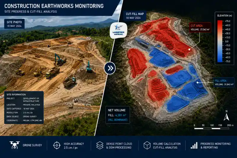
Drone cut fill gives construction project managers, quantity surveyors, and JKR engineers an accurate, independent measurement of earthworks volumes. As a result, it removes the estimation errors and billing disputes that traditional cross-section methods bring to Malaysian sites. Manual methods carry 5% to 15% quantity variance on large earthworks packages. In practice, that variance turns into a payment dispute. Drone surveys instead compare the existing terrain against the design surface at ±2 to 5 cm accuracy. They produce colour-coded cut-fill maps and volume reports within 24 to 48 hours of each flight. So this guide explains how drone cut fill works, when to use it, and what deliverables your team needs.
Key Takeaways
- Drone cut fill measures earthworks volumes by comparing drone-derived surface models against the approved design surface. It reports cut volumes, fill volumes, and net material movement per zone.
- Truck-counting and cross-section methods carry 5% to 15% volume variance on large packages. By contrast, drone measurement reaches ±2 to 5 cm accuracy.
- Cut-fill reports feed directly into AutoCAD Civil 3D. That is the standard earthworks design platform for Malaysian consultants and contractors.
- Drone cut-fill records increasingly serve as independent evidence in CIPAA adjudication. Earthworks quantity disputes are the most common construction payment dispute in Malaysia.
What Is Drone Cut Fill?
Cut and fill is the process of moving earth on a site. In short, you cut material from high ground and use it to fill low areas until you reach the design formation level. Accurate volume measurement matters throughout the earthworks phase. After all, it drives BOQ reconciliation, payment certification, and material balance management.
Drone cut fill produces these measurements from the air. First, the drone surveys the site and generates a DTM of the current surface. Then the software compares that DTM against the approved design surface. In turn, it calculates the volume cut and filled in each zone since the last survey. The output is a colour-coded cut-fill map and a volume report. Together they show net earthworks progress per section.
Why Traditional Methods Fail on Malaysian Sites
The Truck-Count Problem
Many Malaysian earthworks contractors use truck counting as a proxy for volume. In other words, they record the number of truck loads moved per day and estimate volume from truck capacity. However, this method has two basic problems.
First, trucks are rarely filled to a consistent level. A nominal 10 m³ truck may carry only 7 to 9 m³. It depends on material type, fill level, and driver habit. Moreover, different materials have different in-situ versus loose volume ratios. This is the bulking factor. For example, granitic residual soil in Malaysia typically bulks 20% to 30% in loose form. So truck counts without accurate bulking factors overestimate the volume moved.
Second, truck counting cannot separate productive movement from disposal. Material moved from cut to fill on the same site looks identical to material hauled offsite. As a result, accurate material balance becomes impossible.
The Cross-Section Survey Problem
Cross-section surveying is more accurate than truck counting. Here, ground teams traverse the site and record elevation points at set intervals. Still, it introduces real error on active sites. The reason is simple. Cross-sections sample the ground at specific points, not across the whole surface. Therefore, complex features between sample points are approximated rather than measured. On sites with cut batters, fill slopes, and road embankments, that approximation error adds up across large areas.
Drone cut fill removes both problems. The drone captures the entire surface at millions of points per flight. Consequently, the DTM reflects actual ground conditions in full, not by approximation.
How Drone Cut Fill Works
Step 1: Baseline Survey
Before earthworks begin, a baseline flight captures the pre-earthworks ground surface. This DTM sets the starting point for every cut and fill volume that follows. Sometimes earthworks are already underway when surveys begin. In that case, the first flight sets the baseline from that point instead.
Step 2: Design Surface Import
Next, the approved design surface goes into the processing workflow. Usually this is a Civil 3D TIN surface. It defines the target formation level across the site.
The software then compares the current DTM against that design surface. As a result, it produces two datasets. Cut areas show where the ground sits above design level, so material still needs removing. Fill areas show where the ground sits below design level, so material still needs adding.
Step 3: Periodic Survey Flights
After that, flights repeat weekly or fortnightly through the earthworks phase. Each new DTM is compared two ways:
- Against the previous survey DTM: this shows volume moved in the period, which verifies progress payments.
- Against the design surface: this shows the cut and fill still remaining to completion.
So this dual comparison answers both key questions at once. It measures what has been achieved and what still remains. Those are the two things earthworks contract management needs at every reporting cycle.
Step 4: Cut-Fill Report Delivery
Finally, the software generates a colour-coded cut-fill map and volume report within 24 to 48 hours. The report usually includes:
| Output | Format | Use |
|---|---|---|
| Cut-fill map | PDF, GeoTIFF | Visual progress overview |
| Cut volume by zone | Excel, PDF | BOQ reconciliation per section |
| Fill volume by zone | Excel, PDF | BOQ reconciliation per section |
| Net material balance | Excel, PDF | Import/export material planning |
| Progress vs design | PDF overlay | Remaining earthworks quantification |
| Civil 3D surface | DWG, LandXML | Engineer’s own analysis |
Malaysian Construction Applications
Housing Scheme Earthworks and HDA Milestones
Malaysian residential developers draw down from the Housing Development Account (HDA) at set milestones. Earthworks completion is one of the earliest. Drone cut fill gives objective, georeferenced evidence that earthworks have reached the approved formation level across the site.
Some developers run several blocks under earthworks at once. In that case, drone surveys document completion block by block. So each block supports a staged HDA drawdown claim as it reaches formation level.
JKR Road Construction and BOQ Verification
JKR road contracts price earthworks on BOQ quantities. Cut and fill volumes are agreed at tender. During construction, monthly progress payments then depend on the volumes verified to date.
Drone cut fill supplies the independent measurement for this. JKR supervising officers and project management consultants use it to check contractor monthly claims. When claimed quantities differ from measured quantities, the drone data is the objective reference.
Industrial Park and Commercial Development
Large flat-pad sites need heavy bulk earthworks. Industrial parks, logistics centres, and commercial developments all bring sloped land to a consistent formation level. Drone cut fill tracks progress across these large sites. By contrast, a manual survey of the whole area would take survey teams several days per visit.
CIPAA Dispute Documentation
The Construction Industry Payment and Adjudication Act 2012 (CIPAA) gives a rapid route for payment disputes. Earthworks quantity disputes are among the most common referrals. Typically, a contractor claims payment for volumes the employer disputes.
Drone cut fill data helps here directly. It provides timestamped, georeferenced, independently processed volume measurements as objective evidence. Moreover, a programme of regular surveys builds a documented record of site conditions at each date. That record is far more persuasive than truck counts or retrospective cross-section surveys.
Accuracy and Bulking Factor
Survey Accuracy
With RTK GPS and proper flight planning, drone cut fill reaches ±2 to 5 cm in surface elevation. In turn, that means roughly ±1% to 3% volume accuracy on large areas. Some projects need tighter accuracy still, such as engineering-grade earthworks with strict formation tolerances. For those, GCP-enhanced surveys bring accuracy to ±1 to 3 cm elevation.
This level is enough for BOQ reconciliation, progress payment certification, and CIPAA evidence.
The Bulking Factor
Drone cut fill measures surface volumes. That means in-situ volumes before excavation and compacted volumes after compaction. However, these figures do not automatically include the bulking factor. Material gains loose volume when excavated, typically 20% to 30% for Malaysian residual soils. Then it loses volume again once compacted.
So always confirm one thing with your project team for BOQ purposes. Check whether the contract quantifies earthworks in in-situ measure or loose measure. Then apply the right bulking factor to the drone-measured volumes.
CAAM and JUPEM Compliance
Every drone cut fill operation needs approvals before deployment.
CAAM ATF: First, all commercial drone operations need an Authorisation to Fly from CAAM. Apply at least 14 working days before the survey.
JUPEM APK Permit: Drone cut fill surveys also capture georeferenced aerial data. Because of that, they trigger the JUPEM aerial data acquisition security clearance. For regular monthly or weekly surveys, use one programme-level APK application covering the full period. It is more efficient than individual per-survey applications.
For a full permit guide, read our drone permit Malaysia requirements guide.
Frequently Asked Questions
How accurate is drone cut fill compared to traditional cross-section surveys?
Traditional cross-section methods carry 5% to 15% variance on large packages. This comes from the approximation between survey stations. Drone cut fill instead reaches ±2 to 5 cm surface accuracy across the full site. In turn, that means roughly ±1% to 3% volume accuracy. On large contracts, 5% variance can represent a big payment amount. So drone measurement gives real financial protection to both contractor and employer.
How often should earthworks sites schedule drone cut fill surveys?
It depends on how fast the site is moving. Active sites shifting large volumes daily benefit from weekly surveys. These align with weekly progress reviews and stop variances from building up. Slower sites suit fortnightly surveys, such as during final grading or compaction. Monthly surveys are the minimum for an auditable record for CIPAA purposes.
Can drone cut fill reports be used as evidence in CIPAA adjudication?
Yes. Drone-derived DTMs and cut-fill reports are accepted as independent, objective evidence in CIPAA proceedings. However, a few conditions apply. The survey must be run by a competent operator and processed with photogrammetry or LiDAR software. It must also be georeferenced with documented accuracy and date-stamped at capture. In practice, regular survey programmes with consistent methodology produce the strongest evidence.
How does drone cut fill output integrate with AutoCAD Civil 3D?
Civil 3D is the standard earthworks platform for Malaysian consultants. Drone cut fill providers deliver LandXML surface files and DWG-compatible TIN surfaces. These import straight into Civil 3D. Then your user compares the drone existing surface against the design surface with the volume dashboard. From there, they generate cross-sections, earthworks reports, and material balance calculations inside the workflow they already use.
Conclusion
Drone cut fill takes the guesswork out of earthworks measurement. Instead of truck counts and cross-section approximations, you get direct surface measurement at ±2 to 5 cm across the whole site.
For Malaysian project managers, the benefit is simple. Weekly or fortnightly surveys cost far less than the disputes and rework that pile up when quantities are not measured well. Moreover, the Civil 3D-compatible output drops straight into the workflows consultants and contractors already run.
LangiTech Aerial provides CAAM and JUPEM-compliant drone cut fill services across Peninsula Malaysia. This covers housing scheme earthworks, JKR road construction, industrial park development, and any project that needs accurate, independent earthworks volume measurement.
Contact LangiTech Aerial to talk through your earthworks survey and get a programme quote.
For a broader look at drone construction survey applications, read our drone progress monitoring Malaysia guide.
Need Help Planning a Compliant Drone Project in Malaysia?
Speak with our team about commercial drone operations, compliance requirements, and the right aerial solution for your project.