
3D Mapping & Surveying
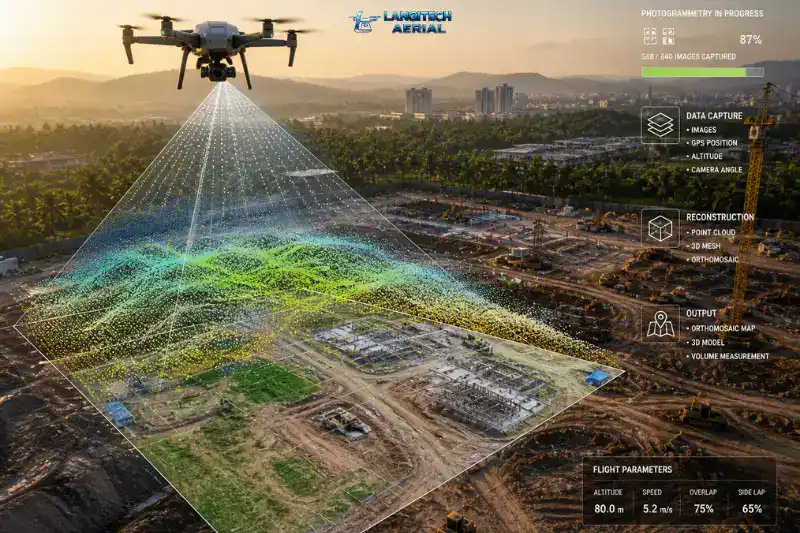
Photogrammetry Malaysia is the standard method that engineers, surveyors, and developers use to turn drone imagery into accurate, measurable maps and 3D models. Instead of sending ground crews across large or difficult terrain, a single drone flight captures thousands of overlapping images. Specialised software then reconstructs those images into georeferenced spatial data your team can measure, analyse, and feed directly into CAD and GIS workflows. This guide explains how the process works, what you receive, and when photogrammetry is the right choice for your project.
Key Takeaways
- Photogrammetry Malaysia turns overlapping drone images into orthomosaic maps, elevation models, and 3D point clouds
- RTK-enabled workflows achieve ±2 to 5 cm horizontal accuracy — suitable for construction, land development, and plantation surveys
- Photogrammetry is the most cost-effective aerial survey method for open and semi-open terrain; LiDAR is the better choice for dense vegetation
- All commercial photogrammetry drone operations in Malaysia require a CAAM ATF and a JUPEM APK permit before flight
What Is Photogrammetry Malaysia?
Photogrammetry Malaysia is the science of extracting accurate measurements and 3D geometry from overlapping aerial photographs captured by a drone. The process works by identifying common features across hundreds of images shot from slightly different positions. Specialised software uses these shared reference points to calculate precise distances, elevations, and spatial relationships across the entire survey area.
The result is not simply a mosaic of aerial photos. Instead, every output carries real-world georeferencing — meaning your team can measure distances, calculate volumes, and extract elevation data with confidence. Photogrammetry Malaysia therefore bridges the gap between aerial imagery and survey-grade spatial data, at a fraction of the cost of traditional ground surveys.
How Drone Photogrammetry Malaysia Works: Step by Step
Step 1 — Mission Planning and Permit Approvals
Before the drone takes off, the operator programs the flight mission and secures the required regulatory approvals. Commercial photogrammetry Malaysia operations need two separate permits — an Authorisation to Fly (ATF) from CAAM and an APK aerial data permit from JUPEM. Both approvals take at least 14 working days to process. Factor this into your project schedule early to avoid delays.
Step 2 — Aerial Image Capture
The drone flies a pre-programmed grid pattern over the survey area, typically at 80 to 150 metres above ground level. Throughout the flight, it captures high-resolution images with a frontal overlap of 70 to 80% and a side overlap of 60 to 70%. This level of overlap is essential — it gives the processing software enough shared visual content to accurately reconstruct 3D geometry across the site.
RTK (Real-Time Kinematic) GPS technology geotags each image to a precise coordinate during the flight. As a result, the processing stage requires fewer Ground Control Points (GCPs) — reducing field time and cost considerably.
Step 3 — Photogrammetry Processing
Back at the office, the team processes the images through photogrammetry software — typically Pix4D, DJI Terra, or Agisoft Metashape. The software identifies common features across thousands of overlapping frames and uses these to reconstruct the 3D geometry of the site. It then generates all requested deliverables, checks accuracy against reference points, and exports the final outputs in your required file formats.
What Photogrammetry Malaysia Delivers
Orthomosaic Map
The orthomosaic is a distortion-free, georeferenced aerial map stitched from every captured image. Each pixel carries a precise real-world coordinate. Your team can therefore measure distances, calculate areas, and use the orthomosaic as a reliable base layer in GIS or CAD software — something a regular drone photo cannot provide.
DSM and DTM Elevation Models
The processing pipeline generates two elevation outputs from the photogrammetry data. A Digital Surface Model (DSM) captures the top of everything on site — trees, buildings, stockpiles, and structures. A Digital Terrain Model (DTM), by contrast, represents only the bare ground surface, with above-ground features stripped out. Both outputs support earthworks planning, drainage design, and cut-and-fill reporting.
3D Point Cloud
The photogrammetry software builds a dense point cloud — a three-dimensional dataset of georeferenced points representing the entire survey surface. Engineers use point clouds for BIM integration, structural documentation, volumetric calculations, and detailed site analysis. Furthermore, the point cloud serves as the raw data source from which all other 3D outputs derive.
Volumetric Report
Software tools calculate cut-and-fill volumes and stockpile quantities directly from the point cloud or DSM. This is particularly valuable on construction and quarrying projects where manual stockpile measurement is slow and error-prone. Notably, volumetric reports from photogrammetry data are now a standard deliverable on most major Malaysian infrastructure and development projects.
Contour Lines and Topographic Map
The DTM generates standard contour line data for use in AutoCAD and Civil 3D. This output supports early-stage earthworks design, drainage modelling, and infrastructure alignment planning. It is therefore one of the first deliverables requested on pre-construction photogrammetry Malaysia projects.
Photogrammetry Malaysia Accuracy: What to Expect
With RTK-enabled drones and a disciplined flight workflow, photogrammetry Malaysia achieves horizontal accuracy of ±2 to 5 cm and vertical accuracy of ±3 to 7 cm under normal conditions. Academic and field studies consistently confirm these ranges for RTK and PPK workflows with well-distributed checkpoints.
For projects requiring tighter tolerances, additional Ground Control Points (GCPs) — physical markers surveyed by GPS before the flight — further improve absolute accuracy. In those cases, horizontal accuracy of ±1 to 3 cm is achievable.
Several factors affect where in that range a project lands:
- Flight altitude: Lower altitude produces higher image resolution and finer accuracy. Flying at 50 to 80 metres achieves higher GSD than flying at 120 to 150 metres.
- GCP density and distribution: More GCPs, better distributed across the site, reduce error — particularly at site edges.
- Surface type: Reflective or featureless surfaces — such as water, smooth concrete, or dry sand — challenge photogrammetry processing. These are areas where LiDAR performs more reliably.
Where Photogrammetry Malaysia Is Used
Photogrammetry Malaysia supports a wide range of industry applications across the country.
Construction and land development: Pre-construction topographic surveys, earthworks progress tracking, cut-and-fill volumetrics, and as-built verification are all standard uses. Moreover, monthly progress flights give project managers a measurable, documented record of site development over time.
Plantation and agriculture: Estate managers use photogrammetry Malaysia to produce plantation inventory maps, identify block boundaries, assess canopy conditions, and plan road and drainage layouts. Combined with multispectral sensors, the same flight additionally produces crop health index maps (NDVI/SAVI) for precision agriculture decisions.
Infrastructure and utilities: Road and highway corridor surveys, pipeline route planning, and bridge and dam inspection documentation all rely on photogrammetry Malaysia outputs. Furthermore, infrastructure teams use regular repeat surveys to detect change and monitor structural conditions over time.
Forestry and environmental: Government agencies and environmental consultants use photogrammetry Malaysia for forest boundary mapping, biodiversity surveys, and flood-risk documentation. However, for dense forest canopy where ground terrain data is needed, LiDAR is the more appropriate choice.
For a full breakdown of applications, read our drone mapping Malaysia complete guide.
Photogrammetry Malaysia vs LiDAR: When to Choose Each
Both photogrammetry and LiDAR produce 3D point clouds and elevation models. However, they achieve this through fundamentally different methods — and each has clear strengths.
Photogrammetry uses overlapping camera images and works best on open, semi-open, or partially vegetated terrain. It produces photorealistic outputs, costs less, and suits the majority of Malaysian construction, plantation, and land development projects.
LiDAR sends thousands of laser pulses per second and measures their return time. Unlike photogrammetry, laser pulses penetrate gaps in vegetation to reach the ground beneath the canopy. This makes LiDAR the better choice for dense forest surveys, infrastructure corridors in heavily vegetated terrain, and any project where ground-level terrain data under canopy is critical.
In practice, most photogrammetry Malaysia projects in construction and open-plantation contexts produce results that match or exceed project accuracy requirements. Switch to LiDAR when you specifically need under-canopy terrain data or when the site has dense, tall vegetation that photogrammetry cannot penetrate reliably.
For a detailed comparison, read our LiDAR vs photogrammetry drone survey Malaysia guide.
CAAM and JUPEM Compliance for Photogrammetry Malaysia
Every commercial photogrammetry Malaysia drone operation requires two regulatory approvals — and many clients only know about one of them.
CAAM ATF: CAAM requires an Authorisation to Fly for all commercial drone operations under the Civil Aviation Regulations 2016. Your provider applies through the ASOS portal at least 14 working days before the flight. Their pilots must also hold the RCoC-B certification.
JUPEM APK Permit: For any drone operation that captures aerial data — including photogrammetry — JUPEM requires a separate APK security clearance permit. This step is mandatory and is separate from the CAAM ATF. Always confirm that your provider handles both applications before engaging them.
For a complete breakdown, read our CAAM drone regulations Malaysia guide.
Frequently Asked Questions
What is the difference between photogrammetry and a regular drone photo?
A regular drone photo captures a single image for visual purposes. Photogrammetry Malaysia, by contrast, captures hundreds of overlapping images and processes them into georeferenced, measurable outputs — orthomosaics, elevation models, and 3D point clouds. The outputs carry real-world coordinates, so your team can take precise measurements from them. A regular drone photo cannot provide this.
Is photogrammetry Malaysia accurate enough for engineering projects?
Yes — for most construction, land development, and infrastructure applications. With RTK GPS and a well-planned flight, photogrammetry Malaysia routinely achieves ±2 to 5 cm horizontal accuracy. For tighter tolerances, GCPs bring this closer to ±1 to 3 cm. Always ask your provider to confirm their accuracy methodology and provide a checkpoint report with deliverables.
How long does a photogrammetry Malaysia project take?
Field capture for a 10 to 50 hectare site typically takes one day. Processing and deliverable preparation then takes two to five working days, depending on the scope and deliverable complexity. In addition, CAAM and JUPEM approvals add 14 to 21 working days to the pre-flight phase. Build this into your project schedule from the start.
When should I use LiDAR instead of photogrammetry Malaysia?
Choose LiDAR when your project involves dense forest canopy, tall vegetation, or requires ground-level terrain data beneath a vegetated surface. For open construction sites, cleared plantations, and most land development surveys, photogrammetry Malaysia delivers equivalent accuracy at a lower cost. If you are unsure, ask your provider to assess the site conditions before recommending a method.
Conclusion
Photogrammetry Malaysia gives engineers, developers, and project managers a fast, cost-effective route to survey-grade spatial data. It turns a drone flight into an orthomosaic, elevation model, point cloud, and volumetric report — all in one workflow, at a fraction of the time and cost of traditional ground surveys.
The key is choosing a CAAM and JUPEM-compliant provider with RTK-capable equipment, a disciplined processing workflow, and deliverables in formats ready for your engineering team.
LangiTech Aerial provides professional photogrammetry Malaysia services across Peninsula Malaysia. We manage all permit applications and deliver survey-grade outputs in formats your team can use immediately.
Contact LangiTech Aerial to discuss your project and get a quote.
For a broader overview of our aerial survey services, read our drone survey Malaysia guide.
Need Help Planning a Compliant Drone Project in Malaysia?
Speak with our team about commercial drone operations, compliance requirements, and the right aerial solution for your project.