
3D Mapping & Surveying
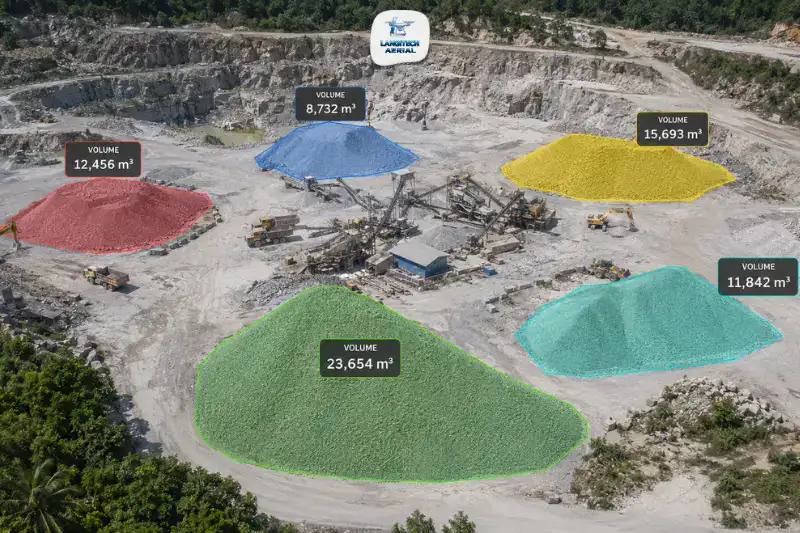
Drone stockpile measurement Malaysia gives quarry operators, construction managers, and industrial teams a fast, accurate way to calculate material volumes. Sending survey crews into active stockpile areas is no longer necessary. Traditional measurement requires total stations, tape measures, and manual calculations. It is slow, exposes surveyors to site hazards, and produces results that are often days old. A drone, by contrast, covers the same stockpile in minutes and delivers volumetric data accurate to within 1% to 3% of ground truth. This guide explains how it works, which industries use it, what it costs, and what permits your provider must hold.
Key Takeaways
- Drone stockpile measurement Malaysia delivers volumetric accuracy of ±1% to 3% — comparable to traditional total station methods — in a fraction of the time
- Key applications include granite quarries, construction earthworks, palm oil mills, aggregate yards, and cement raw material storage
- Regular drone surveys reduce inventory write-offs and improve BOQ reconciliation accuracy on Malaysian construction projects
- All commercial operations require both a CAAM ATF and a JUPEM APK aerial data permit before any flight
What Is Drone Stockpile Measurement Malaysia?
Drone stockpile measurement Malaysia uses UAV photogrammetry to calculate stockpile volumes from the air. The drone flies a pre-programmed grid pattern, capturing hundreds of overlapping images with GPS coordinates. Photogrammetry software then processes these images into a precise 3D surface model of each stockpile. It calculates volume by comparing the 3D surface against a defined base plane — the ground level before the stockpile was created.
The result is a volumetric report delivered within 24 to 48 hours of the flight. Furthermore, repeat surveys over time show how stockpile volumes change between periods, supporting production planning and compliance reporting.
Why Traditional Stockpile Measurement Falls Short
Traditional stockpile volume measurement in Malaysia relies on ground survey teams with total stations or tape measures. These teams physically traverse the stockpile surface and record elevation points manually.
This approach has three persistent limitations. First, it exposes survey personnel to active industrial environments — falling material and heavy machinery all present safety risks. Second, measuring large stockpile areas takes hours or days. By the time results reach the operations team, the data is already out of date. Third, traditional methods sample only limited elevation points. Consequently, large areas of the stockpile surface remain unmeasured, introducing estimation error into the final volume.
Drone stockpile measurement Malaysia addresses all three. The drone captures millions of surface points from the air in minutes. Survey personnel stay safely on the ground throughout. As a result, the volumetric calculation reflects the actual stockpile surface at the time of the flight — not a sparse-point approximation.
Accuracy of Drone Stockpile Measurement Malaysia
Accuracy is the most important specification for any stockpile measurement system. Inaccurate volume data leads directly to financial losses and compliance failures.
Research in Frontiers: Built Environment compared drone and traditional survey methods on quarry stockpiles. It found drone photogrammetry delivered results within 1% variation of ground truth. Separately, Candrone’s data shows a 10-minute drone flight producing volume measurements within ±2.6% of meticulous tape surveys.
For Malaysian quarry and construction operators, therefore, drone stockpile measurement Malaysia matches traditional survey accuracy. It achieves this at a fraction of the time and without exposing personnel to stockpile hazards.
Factors that affect accuracy include:
- Ground Control Points (GCPs): Placing surveyed GCP markers around the stockpile base improves absolute accuracy to ±1% or better
- RTK GPS: Drones with real-time kinematic GPS achieve high relative accuracy without requiring extensive GCP networks
- Stockpile surface texture: Smooth, uniform surfaces produce better photogrammetry results than very fine dust or highly reflective materials
Industries Using Drone Stockpile Measurement Malaysia
Quarrying — Granite, Limestone, Sand, and Aggregate
Malaysia’s quarrying sector covers granite and limestone extraction in Perak, Johor, Pahang, and Selangor. It generates large material stockpiles that operators must measure regularly for inventory management and regulatory reporting.
Quarry operators licensed under JMG (Jabatan Mineral dan Geosains Malaysia) face reporting obligations requiring accurate volume data. Specifically, royalty calculations and production returns both depend on reliable stockpile figures. Drone stockpile measurement Malaysia enables operators to produce monthly volumetric reports efficiently — replacing manual survey teams that previously disrupted operations.
A single quarry drone survey covering 5 to 10 stockpile areas completes in under two hours. The same exercise with traditional methods takes one to two days. Consequently, monthly measurement frequency becomes operationally feasible with drone technology — something most Malaysian quarries previously managed only quarterly.
Construction Earthworks — Cut and Fill Reconciliation
Active construction sites in Malaysia accumulate large earthworks stockpiles — cut material staged before final disposal or reuse, fill material held before compaction, and imported bulk materials awaiting placement.
Accurate cut-and-fill volumetric reconciliation directly affects BOQ management on Malaysian construction projects. This covers housing schemes, industrial parks, and infrastructure corridors alike. Drone stockpile measurement Malaysia delivers monthly or fortnightly earthworks stockpile reports. Project managers use these to reconcile material movements against approved BOQs and earthworks contracts.
Furthermore, regular surveys document the volume of material on site at specific dates. This provides objective evidence for disputes between contractors and employers over earthworks quantities.
Palm Oil Processing Mills — FFB and Residue Stockpiles
Palm oil mills maintain stockpiles of fresh fruit bunches (FFB) awaiting processing. They also hold empty fruit bunches (EFB), palm kernel shells, and other residue materials. Accurate volumes support mill throughput planning, logistics scheduling, and biomass energy reporting.
Drone stockpile measurement Malaysia gives mill managers accurate FFB and residue volumes without requiring personnel to enter stockpile areas. This is a relevant safety consideration — EFB stockpiles are unstable and high-temperature by nature.
Cement Plants and Raw Material Storage
Cement plants in Malaysia maintain large stockpiles of limestone, clay, silica, and other raw materials. Accurate inventory data supports production planning and procurement scheduling. Drone surveys therefore replace manual tape exercises that production teams previously conducted during planned shutdowns.
Coal and Biomass Storage
Power generation facilities and industrial boiler operators use drone stockpile measurement Malaysia to track fuel inventory. Monthly drone surveys provide reliable calorific fuel stock data for operational planning. Moreover, they eliminate the safety risks of manual pile walking entirely.
The Financial Impact of Inaccurate Stockpile Measurement
Inaccurate stockpile volumes have direct financial consequences. Research cited by Candrone shows a single quarry underestimating by 10,000 cubic metres can face write-offs of USD 60,000 to USD 70,000. In one documented case, tightening calculations revealed over USD 100,000 worth of material that previous surveys had missed.
For Malaysian quarry operators, accurate measurement also protects against JMG royalty overpayment. A 3% overestimate on 500,000 cubic metres of annual production represents significant overstated payments.
Drone stockpile measurement Malaysia reduces this financial exposure by providing consistent, auditable volumetric data. External auditors and JMG regulators increasingly accept drone-derived reports as primary stockpile evidence. They recognise their accuracy and auditability over manual survey alternatives.
CAAM and JUPEM Compliance for Drone Stockpile Measurement Malaysia
Every commercial drone stockpile measurement Malaysia operation requires two regulatory approvals — and many operators only know about one.
CAAM ATF: All commercial drone operations require an Authorisation to Fly from CAAM at least 14 working days before the survey. The ATF covers the specific site, dates, and flight parameters.
JUPEM APK Permit: Drone stockpile measurement captures georeferenced aerial data over Malaysian territory. This triggers the JUPEM aerial data acquisition security clearance requirement. The operator must apply for the APK permit through the eBiz JUPEM portal first. The JUPEM approval letter is then a required supporting document for the CAAM ATF application.
A professional drone stockpile measurement Malaysia provider manages both permit applications as part of their service. Always confirm this before engaging a provider.
For the full compliance guide, read our JUPEM permit drone Malaysia guide.
Drone Stockpile Measurement Malaysia: Cost and Turnaround
Cost Ranges (2026)
| Site Type / Number of Stockpiles | Typical Range (RM) |
|---|---|
| Single stockpile, small site | RM 800 – RM 2,000 |
| Quarry with 5–10 stockpiles | RM 2,500 – RM 6,000 |
| Large construction site earthworks | RM 3,000 – RM 8,000 |
| Monthly contracted programme (per visit) | RM 1,500 – RM 4,000 |
Monthly programme rates are significantly lower per visit than one-off survey rates. If your operation requires regular volumetric reporting — for JMG compliance, BOQ reconciliation, or internal inventory management — a contracted programme therefore delivers meaningful cost savings over individual bookings.
Turnaround
Most drone stockpile measurement Malaysia surveys complete data capture in under two hours on site. Photogrammetry processing and volumetric report delivery typically takes 24 to 48 hours after the flight. Combined with CAAM and JUPEM permit processing (14 to 21 working days lead time), plan your first survey booking well in advance of your reporting deadline.
For a full breakdown of drone mapping costs, read our drone mapping cost Malaysia guide.
Frequently Asked Questions
How accurate is drone stockpile measurement Malaysia?
With RTK GPS and proper flight planning, drone stockpile measurement Malaysia achieves volumetric accuracy of ±1% to 3% of ground truth. Adding Ground Control Points (GCPs) around the stockpile base improves accuracy further — to ±1% or better in most conditions. This matches or exceeds the practical accuracy of traditional tape-and-total-station methods, at a fraction of the time.
How often should quarries in Malaysia measure stockpiles by drone?
Most Malaysian quarries benefit from monthly stockpile surveys — aligning with JMG production return periods and internal inventory reconciliation cycles. Construction sites with active earthworks movements benefit from fortnightly surveys during peak earthworks activity. Palm oil mills typically survey weekly or bi-weekly during peak harvest seasons.
Do drone stockpile surveys count for JMG quarry reporting in Malaysia?
Yes. Drone-derived volumetric reports — produced by RTK-enabled photogrammetry with documented GCPs — provide the accuracy and auditability that JMG requires for production return submissions. Ensure your provider delivers a full volumetric report with accuracy documentation, GCP records, and CAAM/JUPEM permit copies. These supporting documents strengthen the auditability of your JMG submission.
Can drone stockpile measurement Malaysia work on irregular or very large stockpiles?
Yes. Photogrammetry-based drone surveys handle irregular stockpile shapes, multiple stockpile areas, and large site footprints effectively. The drone captures millions of surface points across the entire survey area in a single flight — regardless of stockpile geometry. Very large sites covering multiple hectares may require multiple flight sorties, which your provider plans as part of the mission design.
Conclusion
Drone stockpile measurement Malaysia gives quarry operators, construction project managers, and industrial facility teams accurate, frequent, and auditable volume data — without the safety risk, time cost, or operational disruption of traditional ground survey methods.
The financial case is clear. Inaccurate stockpile estimates lead to inventory write-offs, regulatory overpayment, and BOQ disputes. Regular drone surveys — monthly for quarries, fortnightly for active construction sites — eliminate these losses at a fraction of the cost of the errors they prevent.
LangiTech Aerial provides CAAM and JUPEM-compliant drone stockpile measurement Malaysia services across Peninsula Malaysia — for quarries, construction sites, palm oil mills, and industrial material storage facilities.
Contact LangiTech Aerial to discuss your stockpile measurement requirements and get a programme quote.
For a broader guide to our drone survey services, read our drone mapping Malaysia complete guide.
Need Help Planning a Compliant Drone Project in Malaysia?
Speak with our team about commercial drone operations, compliance requirements, and the right aerial solution for your project.