
3D Mapping & Surveying
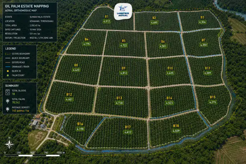
Drone oil palm mapping gives estate managers a complete aerial picture of the plantation. It covers far more than crop health. In fact, it delivers the full range of estate intelligence that ground-based management cannot produce efficiently at scale. That includes palm counting per block, road network condition, drainage mapping, block boundary validation, waterlogging detection, and replanting layout planning. All of it depends on accurate spatial data. Drone mapping delivers that data faster and more completely than any ground survey method. So this guide covers what the technology produces in Malaysia, how each application feeds estate decisions, and how the data fits the MSPO and RSPO reporting frameworks that plantation companies increasingly need.
Key Takeaways
- Drone oil palm mapping covers six applications. These are palm counting, road and infrastructure mapping, block boundary validation, waterlogging detection, replanting layout, and yield estimation support.
- A 500-hectare estate maps completely in under 4 hours of flight time. By contrast, the same coverage on foot takes 2 to 3 weeks.
- The data feeds directly into MSPO Part 3 and RSPO supply chain documentation. As a result, it supports traceability and responsible management reporting.
- Every drone oil palm mapping operation needs a CAAM ATF and a JUPEM APK aerial data permit before deployment.
Why Drone Mapping Changes Oil Palm Estate Management
The Ground Survey Problem
Traditional estate management leans heavily on ground scouting. Field assistants and supervisors walk the blocks to assess palm condition, count gaps, note road damage, and spot drainage problems. However, on a 500-hectare estate, covering everything on foot takes weeks. Worse, the data comes back inconsistent and observer-dependent.
The core limitation is scale. Malaysian oil palm estates run from smallholder plots of a few hectares to group company blocks of 10,000 hectares or more. Mature canopy adds a second problem. By 20 to 25 years, it reaches 10 to 15 metres in height. As a result, it blocks a ground observer’s view, especially of early problems in the upper canopy.
Drone mapping tackles both limitations head on. A single flight day covers 200 to 500 hectares. Moreover, it produces a consistent, georeferenced dataset of every palm row, road section, and drainage channel in the surveyed area.
What Mapping Adds Beyond Spraying
Most estate managers meet drone technology through spraying services. Because of that, there is sometimes a sense that mapping is just a by-product of spraying. It is not. Instead, drone oil palm mapping is a separate, specialist service. It uses different sensors, processing software, and workflows from drone spraying.
The distinction matters. After all, mapping produces the intelligence that drives real decisions. That means replanting schedules, road maintenance budgets, fertiliser zone allocation, and MSPO certification documentation. In short, spraying delivers chemical inputs, while mapping delivers information.
Six Applications of Drone Oil Palm Mapping
1. Palm Counting and Gap Mapping
An accurate palm inventory per block is essential. It drives budgeting, yield projection, and replanting priorities. Traditional counts send field assistants down every row. As a result, the process is slow and prone to errors, especially in large blocks with irregular spacing.
Drone mapping automates the count instead. It uses high-resolution RGB orthomosaic analysis. At 30 to 50 metres altitude, individual palm crowns show up clearly in the imagery. Then the photogrammetry software identifies each crown and counts palms per block automatically. Field verification covers any areas where canopy overlap makes the count ambiguous.
Gap maps show blocks with palm stand below optimal density. Therefore, they support replanting priorities and feed seedling procurement and nursery planning. For example, Genting Plantations uses drone mapping across its 160,000 hectares of oil palms in Malaysia and Indonesia. The group applies it specifically for tree counting and canopy monitoring.
2. Estate Road Network and Infrastructure Mapping
Estate road networks are critical assets. They include main roads, field roads, collection ramps, and bridges. Because they affect harvester access and FFB evacuation, their condition matters. Roads in poor shape slow FFB collection, damage equipment, and create spillage losses.
Drone mapping produces a complete road network map. It identifies road surfaces, culvert locations, bridge condition indicators, and junction layouts across the estate. So that inventory supports annual maintenance budgets. It also lets you prioritise repairs by traffic load and by the condition visible in the orthomosaic.
Culvert mapping adds further value. It records drainage crossings that are otherwise hard to log. A culvert in poor condition floods the road in heavy rain. Consequently, that becomes yield loss during peak harvest.
3. Block Boundary Validation
Oil palm estates sometimes have gaps between title and reality. In other words, the registered land title boundaries and the actual planted areas do not match. These gaps come from old survey inaccuracies, encroachment over time, or informal land use changes.
Drone mapping produces georeferenced block boundary maps. As a result, you can compare them directly against title survey data. Boundary discrepancies then show up clearly in the orthomosaic. That includes encroachment onto adjacent land, unplanted areas inside registered boundaries, and poorly defined inter-block divisions. Better still, each one can be quantified accurately.
This matters more every year for MSPO and RSPO certification. Both require estates to show that planted areas match legally registered land. For instance, RSPO Principle 2 requires compliance with applicable laws, including land rights. Boundary validation gives auditors the documentary evidence they need.
4. Waterlogging and Drainage Failure Detection
Waterlogging is one of the biggest yield killers on Malaysian estates. It shows up most in the low-lying coastal and alluvial areas of Johor, Selangor, Sabah, and Sarawak. When it persists, it cuts root respiration and impairs nutrient uptake. As a result, FFB yield drops.
Detecting it from the ground is inconsistent. After all, supervisors may not visit waterlogged areas during dry spells, when the problem is invisible. Drone mapping captures drainage conditions from above instead. It reveals standing water, blocked channels, and ponding patterns that point to drainage failure.
Orthomosaics flown shortly after heavy rain are especially telling. The water accumulation patterns pinpoint drainage failures and low-lying areas that need work. Consequently, drainage programmes built on this data put the interventions where they do the most for yield.
5. Replanting Layout Planning
Replanting is the most capital-intensive event in the estate cycle. The new layout covers block configuration, road network, drainage design, and terrace alignment on slopes. In turn, it sets the productivity and maintenance cost of the estate for the next 25-year rotation.
Drone mapping generates the DTM and orthomosaic data for this work. Layout planners then use it to design the new configuration.
- DTM for terrace design: On slopes, terraces follow topographic contours. So a drone-derived DTM gives the terrain model that terrace alignments are designed from. This limits erosion and helps optimise planting density.
- Drainage layout: DTMs show natural drainage directions and low-lying collection points. As a result, channels can be designed to work with the topography rather than against it.
- Road network planning: Planners overlay existing road positions on the DTM data. Then they set new road alignments by gradient, which cuts construction cost and long-term erosion maintenance.
MySpatial Malaysia names replanting layout planning as a primary drone UAV application for Malaysian oil palm. Specifically, it notes that a drone survey produces the blueprint for block, main road, sub-road, drainage, nursery, and terrace design.
6. Yield Estimation Support
Palm canopy area tracks yield potential. In other words, the size and condition of the crown from above reflects photosynthetic capacity. Because of that link, drone mapping supports block-level canopy coverage analysis. This feeds yield estimation for crop forecasting.
Some blocks show below-average canopy density. That points to poor nutrition, water stress, or disease pressure. So those blocks flag as yield-risk areas that need agronomic attention. Ideally, you act before the deficiency reaches FFB production. As a result, you intervene in a targeted way rather than react after yield falls short.
MSPO and RSPO Documentation from Drone Mapping
Malaysian plantation companies work under MSPO Part 3 and RSPO certification. MSPO Part 3 covers independent smallholders and group certification. RSPO stands for the Roundtable on Sustainable Palm Oil. Increasingly, both groups use drone mapping data to support their documentation.
Here are the main certification benefits:
- Block area verification: Drone-derived block area measurements support land use records under MSPO Criterion 2.1 and RSPO Principle 2.
- Boundary documentation: Orthomosaic boundary maps provide georeferenced estate boundary records.
- Infrastructure inventory: Road and drainage records support responsible management documentation.
- Waterlogging records: Drainage condition monitoring supports good agricultural practice documentation.
Multispectral crop health mapping is the complementary service for NDVI-based canopy monitoring. For a full guide, read our multispectral mapping Malaysia guide.
CAAM and JUPEM Compliance
Every drone oil palm mapping operation needs two approvals.
CAAM ATF: First, all commercial drone operations need an Authorisation to Fly from CAAM. Submit it at least 14 working days before deployment. Estate mapping over large plantation areas makes for a straightforward application. The main things to check are proximity to nearby infrastructure and the airspace classification of the estate.
JUPEM APK Permit: Estate mapping also captures georeferenced aerial data. Because of that, it triggers the JUPEM aerial data acquisition security clearance. For a large programme covering multiple blocks over multiple flights, use one programme-level APK application. It covers the estate extent and the planned survey period, so it beats individual per-flight applications.
For a full permit guide, read our drone permit Malaysia requirements guide.
Frequently Asked Questions
How does drone oil palm mapping differ from multispectral crop health surveys?
Both fly drones over oil palm estates. However, they serve different purposes. Drone oil palm mapping mainly uses RGB cameras. It produces orthomosaics and terrain models for palm counting, infrastructure mapping, boundary validation, and replanting planning. Multispectral surveys use NIR and red-edge sensors instead. They produce NDVI and NDRE crop health maps for agronomic monitoring. In practice, the most complete programmes run both. RGB handles infrastructure and inventory, while multispectral handles canopy health.
How often should oil palm estates run drone mapping surveys?
It depends on the application. For example, palm counting and boundary validation suit an annual cadence or a survey at replanting. Road and infrastructure mapping works annually or after major weather events. Waterlogging detection is best quarterly, or after heavy rain. Replanting layout survey happens once per rotation, as an area nears replanting. Finally, multispectral canopy monitoring runs quarterly as part of an ongoing agronomic programme.
Can drone oil palm mapping support RSPO audit documentation?
Yes. Drone-derived boundary maps, land use orthomosaics, and infrastructure records are georeferenced and date-stamped. As a result, they support RSPO Principle 2 land rights compliance and responsible management records. For RSPO certification, make sure your provider delivers GeoTIFF orthomosaics, block area calculations, and survey metadata. Then auditors can verify everything on their own.
What is the coverage rate for drone oil palm mapping?
With a multi-rotor RTK drone, a typical estate operation covers 200 to 500 hectares per flight day. So a 3,000-hectare block estate takes 6 to 15 flight days for full coverage. Usually that spreads across 2 to 3 weeks, in order to work around ATF permit windows and weather.
Conclusion
Drone oil palm mapping gives estate managers a complete spatial picture of the plantation. It runs from palm inventory and road condition to drainage failures and replanting layout data. In short, it is the mapping foundation under nearly every other estate decision. That reaches from annual budgets to MSPO certification to 25-year replanting cycles.
Malaysia’s largest estate groups already run it. For mid-size and smaller estates, the case is just as strong. After all, the cost of a mapping programme can be recovered from a single gain in replanting layout, drainage prioritisation, or yield gap identification.
LangiTech Aerial provides CAAM and JUPEM-compliant drone oil palm mapping across Peninsula Malaysia. This covers palm counting, road network surveys, DTM for replanting layout, and full estate orthomosaic programmes.
Contact LangiTech Aerial to talk through your estate mapping needs and get a programme quote.
For a guide to drone crop health monitoring, read our multispectral mapping Malaysia guide. For drone spraying services, read our oil palm drone spraying guide.
Need Help Planning a Compliant Drone Project in Malaysia?
Speak with our team about commercial drone operations, compliance requirements, and the right aerial solution for your project.