
3D Mapping & Surveying
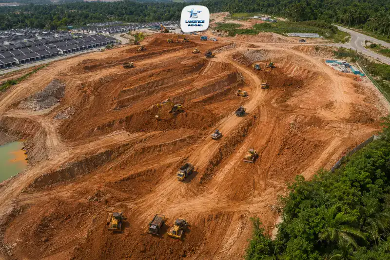
Drone earthworks survey gives project managers, site engineers, and supervising consultants accurate, timely spatial data. It covers every stage of the process, from initial clearing through bulk earthmoving, grade control, compaction verification, slope formation, and drainage. Traditional earthworks surveys on active Malaysian sites are slow, episodic, and hazardous. Survey crews end up working between excavators and haul trucks on loose formation surfaces. A drone covers the whole site in hours from a safe vantage point. So it delivers the data engineers need before the next layer goes down, not after. This guide covers where these surveys add the most value, what the data enables, and how it fits the Malaysian construction workflow.
Key Takeaways
- Drone earthworks surveys can cut survey costs substantially against traditional ground methods, while giving better spatial coverage and data density across the whole site.
- Grade control is the highest-value application. Verifying subgrade formation levels before compaction prevents costly rework that cannot be reversed once fill is compacted.
- Malaysian residual soils, particularly granite and sedimentary residual soils, shrink and swell enough that accurate formation level verification is critical before pavement or slab construction.
- Every drone earthworks survey needs a CAAM ATF and a JUPEM APK aerial data permit before deployment.
Why Earthworks Needs Better Data
The Survey Gap Problem
Malaysian earthworks move a lot of material over long periods, especially on housing scheme, industrial park, and highway projects. Take a typical Phase 1 housing scheme in Selangor or Johor. It moves 500,000 to 2,000,000 cubic metres of residual soil across 20 to 100 hectares.
Traditional survey on these sites uses total station traverses to spot-check formation levels at widely spaced grid points. Those checks cover 2% to 5% of the site area, and the intervening 95% is interpolated. On complex terrain with irregular earthworks progress, that interpolation introduces formation level errors. Over time, those errors compound into drainage failures, structural slab settlement, and pavement distress after construction.
Drone earthworks survey captures millions of surface points across the whole site in a single flight. As a result, you get a complete formation level picture rather than a sparse spot-check approximation.
Malaysian Soil Behaviour
Malaysian residual soils come from in-situ weathering of granite, sedimentary rock, and volcanic material. Their behaviour makes accurate earthworks level verification particularly important, in two ways.
Shrinkage on drying: Malaysian granitic residual soils shrink as they dry. That affects fill settlement if moisture content during compaction is not controlled. A layer placed at the correct loose depth but the wrong moisture content may compact below the design level. Without accurate as-compacted data, the engineer has no way to know.
Swelling under loading: Certain Malaysian sedimentary residual soils swell under surcharge loading, then consolidate progressively. This is common in soils from the Selangor coastal plain. So formation levels measured right after completion can shift over the following 6 to 12 months. That makes an early, accurate baseline critical for monitoring and for any claims.
A drone survey provides the accurate, date-stamped formation baseline for this. It lets you track these soil effects systematically, through construction and after it.
Five Applications Where Drone Surveys Add Most Value
1. Pre-Earthworks Existing Ground Survey
Before bulk earthmoving starts, an accurate existing ground survey establishes the pre-earthworks terrain that all later cut-fill calculations reference. This survey is the foundation of the earthworks BOQ, both for tendering and for monthly progress payment verification.
Drone earthworks survey captures this surface faster and at higher point density than any ground method. The resulting DTM feeds directly into AutoCAD Civil 3D or equivalent software as the existing ground model. For a detailed guide to earthworks volume calculation, read our drone cut fill Malaysia guide.
2. Grade Control Before Compaction
This is the highest-value application, and the one with the clearest cost justification.
Grade control confirms that the formation surface has been shaped to the correct design level before compaction begins. On a housing scheme, the subgrade formation must match the design platform level within tolerance. That is typically ±50mm under PAM or JKR earthworks specifications. Areas outside tolerance need regrading before compaction.
The critical point is timing, because regrading is only possible before compaction. Once a fill layer is compacted, high areas cannot be removed without breaking the layer. Low areas can only be fixed by adding a thin fill layer on top, which carries its own compaction risks.
So a drone survey before the compaction crew moves in flags every out-of-tolerance area, while correction is still simple and cheap. Run 24 to 48 hours before scheduled compaction, it pays for itself on a single layer correction.
3. Compaction Verification and Layer Documentation
After compaction, a drone survey of the compacted formation documents:
- Actual compacted surface levels against design levels
- Any low areas needing thin lift remediation before the next phase
- Layer completion across the site, confirming which areas have reached final platform level and which are still pending
This layer-by-layer record creates an auditable trail of earthworks completion. It satisfies CIDB quality management requirements and supports supervising consultant certification of earthworks for payment.
4. Slope Formation and Stability Monitoring
Malaysian earthworks involve cut slopes and fill embankments that must comply with approved design angles. Under CIDB requirements and Slope Engineering Branch (JKR) guidelines, slopes must be formed to specified angles. They must also be protected against erosion progressively as earthworks advance.
A drone survey captures actual slope face angles from the air, so you can compare them against the design drawings. Out-of-compliance slopes then show up immediately, rather than at the next manual inspection. That covers faces steeper than design, and fill embankments not adequately benched before each new lift.
Moreover, repeat surveys after rainfall pick up early signs of movement before they turn into failures. Those signs include tension cracking, face displacement, and seepage emergence. This matters especially on Malaysian residual soil slopes above roads and occupied areas.
5. Drainage Formation Verification
Malaysian earthworks include drainage channels, retention ponds, diversion drains, and sedimentation ponds as part of the site stormwater system. Under MSMA guidelines, drainage channels must hold their design gradients to work. Even a 0.1% gradient error on a long flat drain can reverse the flow direction.
Drone surveys of completed drainage formations check as-formed channel gradients against design. They flag reversed-gradient sections and ponding risk before backfilling or paving hides them. This is an essential pre-handover check that manual survey rarely captures in full.
How It Fits Malaysian Construction Workflows
AutoCAD Civil 3D and BIM
Malaysian civil consultants and earthworks contractors mostly use AutoCAD Civil 3D for earthworks design and management. Drone earthworks surveys deliver LandXML and DWG surface files that import straight into Civil 3D. So engineers can run volume calculations, grade analysis, and cross-sections against the latest surveyed surface without leaving their standard workflow.
Some projects above RM10 million fall under the Public Works Department’s BIM mandate. On those, drone point clouds and orthomosaics integrate as as-built reality capture layers in the BIM model. That supports the BIM execution plan requirement for as-built documentation.
CIDB and Supervising Consultant Requirements
In Malaysian practice, works are supervised by a Superintending Officer (SO) or the SO’s Representative. Both come from the PAM or IEM qualified engineering team. Monthly progress assessments and payment certification then depend on the SO’s verification of works completed.
Drone earthworks survey gives the SO and supervising consultant independent, georeferenced formation level data to support payment certification. As a result, it replaces the slow, incomplete manual spot-check surveys that currently underpin most Malaysian earthworks payment verification.
Monthly Progress Reporting
Many projects carry employer monthly reporting requirements. On those, drone flights scheduled monthly or fortnightly generate the site orthomosaics, formation level maps, and progress comparisons that employer representatives and financiers request.
Housing developer projects often carry HDA (Housing Development Account) milestone obligations. There, drone formation surveys give objective evidence that earthworks stages have reached design levels across the development. Read our drone progress monitoring Malaysia guide for the full milestone documentation workflow.
CAAM and JUPEM Compliance
Every drone earthworks survey needs regulatory approval before deployment.
CAAM ATF: An Authorisation to Fly from CAAM is required for every flight, applied for at least 14 working days before the survey. For active sites in urban or peri-urban locations, the ATF covers flights next to existing structures, roads, and utility infrastructure.
JUPEM APK Permit: Because these surveys capture georeferenced aerial data, they need JUPEM aerial data acquisition security clearance. Some projects run weekly or fortnightly surveys through the earthworks phase. For those, one programme-level APK application covering the full period beats individual per-survey applications.
For a full permit guide, read our drone permit Malaysia requirements guide.
Frequently Asked Questions
How does drone grade control differ from traditional formation level survey?
Traditional formation survey uses a total station to check elevation at a sparse grid. That is typically 10 to 20 metre spacing on Malaysian sites, covering less than 5% of the site area. A drone survey instead captures millions of elevation measurements across the whole site. This produces a complete formation surface model at 2 to 5 cm resolution. So engineers can spot every out-of-tolerance area, not just the ones that fall on the manual grid.
When is the ideal time to schedule a drone survey during earthworks?
There are two critical windows. The first is before compaction, within 24 to 48 hours of the surface being shaped but before the crew moves in. That allows grade control corrections while regrading is still possible. The second is after compaction, to confirm as-compacted levels and flag any low areas needing thin lift remediation before the next phase.
Can drone earthworks data be used for CIDB quality management documentation?
Yes. Georeferenced drone formation surveys and orthomosaic documentation meet CIDB quality management requirements for earthworks stage documentation. Just make sure your provider delivers data with full metadata. That means survey date and time, accuracy documentation, CAAM permit reference, and coordinate system, so it supports CIDB file submissions.
Conclusion
Drone earthworks survey removes the data gap that causes costly rework, payment disputes, and slope failures on Malaysian construction sites. Grade control before compaction, compaction layer documentation, slope angle verification, and drainage checks all need accurate, site-wide data. All are now achievable on every project, at a fraction of the cost and time of traditional ground survey.
The survey cost saving is real and repeatable. More importantly, grade control prevents rework. Identifying and correcting out-of-tolerance formation before compaction locks it in can save more than the entire survey budget of a typical housing scheme earthworks package.
LangiTech Aerial provides CAAM and JUPEM-compliant drone earthworks survey services across Peninsula Malaysia. That covers housing schemes, industrial parks, highway construction, and land development programmes.
Contact LangiTech Aerial to talk through your earthworks survey and get a programme quote.
For earthworks BOQ and payment certification guidance, read our drone cut fill Malaysia guide.
Need Help Planning a Compliant Drone Project in Malaysia?
Speak with our team about commercial drone operations, compliance requirements, and the right aerial solution for your project.