
3D Mapping & Surveying
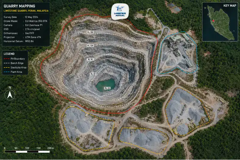
Drone mining survey gives quarry operators, mine managers, and environmental consultants accurate spatial data across every phase of an operation. That runs from initial lease boundary verification through active pit progression monitoring, blasting zone documentation, highwall stability assessment, and final rehabilitation compliance. The sector spans several minerals. It covers granite and limestone extraction across Perak, Selangor, and Johor, iron ore and bauxite in Pahang and Johor, and sand mining along major river corridors. Every operation needs regular surveying for JMG (Jabatan Mineral dan Geosains Malaysia) production reporting, lease compliance, and DOE environmental monitoring. Drone surveys deliver that data faster, more safely, and more accurately than any ground-based alternative.
Key Takeaways
- Drone mining survey covers six applications: lease boundary verification, pit progression mapping, stockpile volumetrics, highwall monitoring, blast zone documentation, and mine rehabilitation surveying.
- JMG-licensed operators need accurate monthly production volume data for royalty calculations and production returns. Drone surveys produce this in hours rather than the days traditional methods take.
- Manual survey in an active quarry exposes personnel to highwall instability, blasting debris, and heavy equipment. Drone surveys remove that exposure entirely.
- Every drone mining survey needs a CAAM ATF and a JUPEM APK aerial data permit before deployment.
Why Malaysian Quarry Operators Need Drone Surveys
Malaysia’s quarrying sector works under a structured regulatory environment managed by JMG, the Department of Minerals and Geoscience Malaysia. Operators licensed by JMG must submit regular production returns documenting extracted volumes, stockpile inventory, and lease boundary compliance. So those obligations call for accurate volumetric and topographic data at monthly or quarterly intervals.
Traditional methods, such as total station traverses, GPS mapping, and manual cross-section measurement, require survey crews to enter active quarry areas. In a working quarry, that means personnel on the pit floor next to haul trucks, near active blasting zones, and below unstable highwall faces. Moreover, manual surveys on large sites of 20 to 100 hectares take several days to finish. As a result, the data is already partly out of date before it reaches the operations team.
Drone mining survey addresses both problems. The drone works from safe standoff positions while mapping the whole quarry at once. A 50-hectare site surveys completely in 2 to 4 hours of flight. Data accuracy runs to ±2 to 5 cm for volume calculations and pit boundary positions.
Six Applications of Drone Mining Survey
1. Quarry Lease Boundary Verification
JMG-issued quarry licences define the permitted extraction boundary precisely. Verifying regularly that active extraction stays within that boundary is both a legal obligation and a financial protection. Extraction outside the approved boundary is an offence under the Mineral Development Act 1994.
Drone mining survey produces georeferenced orthomosaics and boundary maps that overlay the current quarry extent against the approved JMG lease boundary. Monthly or quarterly boundary surveys document compliance objectively, so you have defensible evidence that operations kept to the approved extraction area.
2. Pit Progression Mapping
Open-pit quarrying advances progressively, bench by bench and face by face, as extraction continues. Tracking that progression against the approved mine plan confirms two things. First, that operations follow the approved extraction sequence. Second, that bench heights, face angles, and haul road gradients stay within design.
Drone mining survey produces monthly pit progression maps that record the current geometry, covering face positions, bench elevations, haul road alignments, and remaining lease reserve. These maps feed directly into JMG production returns and internal mine planning reviews.
3. Stockpile Volume Measurement
Accurate stockpile volumes are critical for inventory management, offtake verification, royalty calculation, and production reconciliation. Traditional measurement, whether manual cross-sections or truck-count estimation, carries 10% to 20% volume variance. Over a production year, that accumulates into significant royalty overpayment or inventory write-offs.
Drone mining survey measures stockpile volumes at ±1% to 2% accuracy using RTK photogrammetry. Monthly surveys then track how inventory changes between periods, which supports production planning, sales forecasting, and JMG royalty submissions. For a dedicated guide, read our drone stockpile measurement Malaysia guide.
4. Highwall Stability Monitoring
Highwall faces in open-pit quarries are geotechnically dynamic. Rainfall, blasting vibration, and progressive weathering all change face geometry and stability over time. A highwall failure is one of the most serious safety events in quarrying, with potential consequences for personnel and equipment below.
Drone mining survey supports non-contact highwall monitoring. It captures high-resolution imagery and point cloud data of the face from a safe standoff distance. Repeat surveys at monthly or quarterly intervals then produce change-detection analyses. These flag sections of the highwall where movement or deterioration is developing, before visible warning signs reach the pit floor.
Moreover, after each blast, a drone survey of the blast face documents the rock fragmentation, bench geometry, and any unexpected over-break or under-break. Blast engineers then use that data to optimise subsequent blast designs.
5. Blast Zone Pre and Post Survey
Each blast removes a defined volume of rock from the face. A pre-blast survey of the drill pattern area establishes the existing face geometry. A post-blast survey of the muck pile then captures the fragment distribution and volume removed.
Comparing the two produces a precise measurement of the rock volume released per blast. This directly supports production accounting, explosives consumption tracking, and JMG production records. It also replaces two hazardous tasks: manual face measurement beforehand, and walking measurement of the muck pile afterwards.
6. Mine Rehabilitation and DOE Environmental Monitoring
Malaysian quarry licences include rehabilitation obligations, meaning progressive restoration of previously extracted areas as mining advances. The Department of Environment (DOE) requires evidence of rehabilitation progress as a condition of continued approval.
Drone mining survey produces periodic rehabilitation monitoring surveys, using orthomosaics and terrain models of previously quarried areas. These show vegetation re-establishment, erosion control infrastructure, and slope revegetation progress. As a result, they give DOE auditors and JMG objective, georeferenced documentation they can verify independently.
Malaysian Quarrying Sectors and Survey Requirements
Granite and Limestone Quarrying in Perak, Selangor, Johor, and Pahang
This is Malaysia’s largest quarrying sector by volume. Granite and limestone extraction supplies the construction aggregate, cement raw material, and industrial limestone markets. Perak is the dominant granite and limestone state. Monthly JMG production returns require volumetric data for each stockpile category, including crushed aggregate by grade, overburden, and waste rock.
On these sites, drone mining survey typically runs monthly stockpile surveys aligned with JMG submission periods. It also runs quarterly pit progression surveys for lease compliance, and annual highwall condition surveys.
Iron Ore and Bauxite Operations in Pahang and Johor
Iron ore mining in Pahang and historical bauxite operations in Johor use the same JMG reporting framework. However, they carry additional DOE environmental monitoring obligations, given their higher environmental sensitivity.
On these sites, drone surveys also capture drainage channel conditions, sedimentation pond status, and sediment runoff from exposed working faces. That data supports DOE environmental compliance reporting and demonstrates active environmental management.
Sand Mining Along River Corridors
In-channel and ex-channel sand mining along Malaysian river corridors needs periodic surveys of extraction areas, stockpile volumes, and bank condition. Drone mining survey provides orthomosaic and terrain data for these typically linear, river-adjacent operations. Crucially, it does so without putting personnel near active water extraction equipment.
Drone Mining Survey vs Traditional Methods
| Factor | Traditional Ground Survey | Drone Mining Survey |
|---|---|---|
| Personnel in quarry | Yes, highwall and pit floor | No, drone operates from perimeter |
| Coverage rate (50 ha site) | 3 to 5 days | 2 to 4 hours |
| Stockpile accuracy | ±10 to 20% (estimation) | ±1 to 2% (measured geometry) |
| Highwall monitoring | Impossible without rope access | Safe standoff survey |
| Blast zone survey | Hazardous manual measurement | Safe aerial capture |
| JMG report data | Manual calculation | Automated from DTM / point cloud |
| Repeat frequency | Quarterly at best | Monthly feasible |
CAAM and JUPEM Compliance
Every drone mining survey needs two approvals.
CAAM ATF: All commercial drone operations need an Authorisation to Fly from CAAM, submitted at least 14 working days before the survey. Some quarry sites sit near airports or within controlled airspace, particularly in the Ipoh, Kuala Lumpur, and Johor Bahru corridors. For those, additional ATC coordination may apply.
JUPEM APK Permit: Because these surveys capture georeferenced aerial data, they trigger the JUPEM aerial data acquisition security clearance. For sites running monthly surveys, one programme-level APK application covering the full contract period cuts administrative overhead considerably.
For a full permit guide, read our drone permit Malaysia requirements guide.
Frequently Asked Questions
Does drone survey data satisfy JMG production return requirements?
Yes. Drone-derived volumetric data, produced with RTK positioning and documented GCP accuracy, is accepted for JMG production returns. Make sure your provider delivers a full volumetric report with accuracy documentation, CAAM permit copies, and survey methodology notes. Those supporting documents strengthen the auditability of your submission. For royalty calculation, confirm with your JMG state office which volume measurement standard they accept.
How does drone highwall monitoring improve quarry safety?
Drone highwall monitoring captures face geometry and surface texture from a safe standoff distance, typically 30 to 80 metres from the face. Change-detection analysis between monthly surveys then flags movement, cracking, or tension cracks developing on the face before they become visible from the pit floor. Under DOSH Malaysia’s Occupational Safety and Health Act, operators must manage and monitor highwall hazards. So drone monitoring gives a systematic, documented approach that manual inspection cannot match.
What is the difference between drone stockpile measurement and a full drone mining survey?
Drone stockpile measurement, covered in our stockpile guide, focuses on calculating the volume of material in discrete stockpile areas. A full drone mining survey covers the complete quarry spatial dataset instead. That includes lease boundary, pit extent, bench geometry, haul road alignment, highwall face, stockpile volumes, and rehabilitation areas. Together, these produce the comprehensive record that JMG quarterly reporting, DOE monitoring, and internal mine planning all require.
Conclusion
Drone mining survey turns quarry and open-pit work from an episodic, hazardous data collection exercise into a monthly, safe, and comprehensive spatial intelligence programme. A well-run drone programme serves every JMG reporting obligation, DOE environmental requirement, and internal production need that depends on accurate quarry spatial data.
For quarry operators in Perak, Pahang, Johor, and Selangor, the choice between ground survey and drone survey is increasingly clear. The drone delivers more data, in less time, at better accuracy, with no personnel in the quarry.
LangiTech Aerial provides CAAM and JUPEM-compliant drone mining survey services for granite quarries, limestone operations, iron ore mines, and sand extraction sites across Peninsula Malaysia.
Contact LangiTech Aerial to talk through your quarry survey programme and get a quote.
For a broader overview of the underlying technology, read our drone photogrammetry Malaysia guide.
Need Help Planning a Compliant Drone Project in Malaysia?
Speak with our team about commercial drone operations, compliance requirements, and the right aerial solution for your project.