
3D Mapping & Surveying
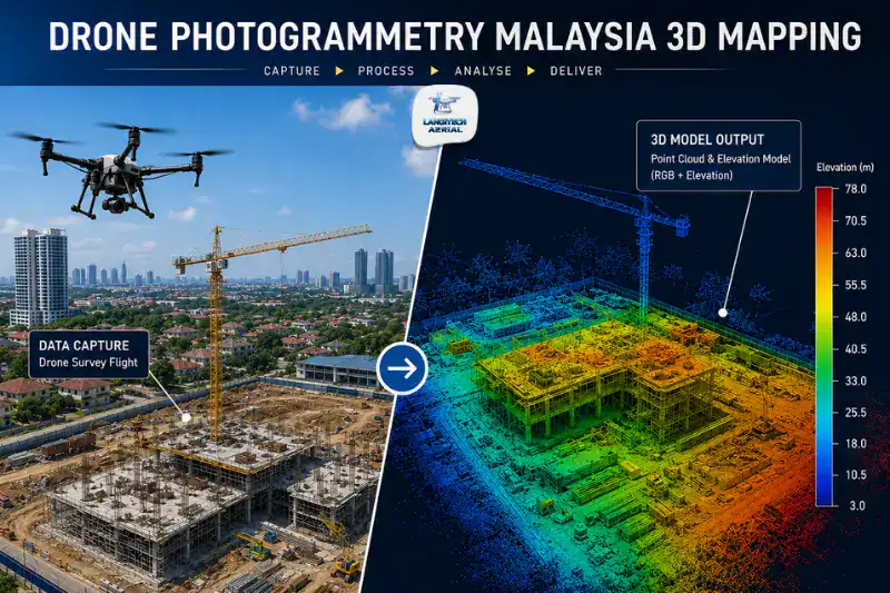
Drone photogrammetry is the technology behind most commercial drone mapping in Malaysia. It turns hundreds of aerial photographs into accurate orthomosaic maps, 3D point clouds, contour models, and volume measurements. If you have ever received a drone survey report with a georeferenced aerial map of your site, a digital terrain model, or a cut-and-fill calculation, photogrammetry produced it. This guide covers how the process works, what it delivers, when to choose it over LiDAR, and what accuracy to expect on Malaysian construction, land development, and plantation projects.
Key Takeaways
- Drone photogrammetry uses overlapping aerial images to reconstruct 3D models of a survey area, producing orthomosaics, DTMs, point clouds, and volume reports.
- For most Malaysian construction, land development, and open plantation surveys, RGB photogrammetry is the right starting point. It is faster and cheaper than LiDAR on open terrain.
- Standard RTK-enabled photogrammetry delivers ±2 to 5 cm horizontal accuracy, which covers most construction and development work without extra ground control.
- Every drone photogrammetry survey in Malaysia needs both a CAAM ATF and a JUPEM APK aerial data permit before the flight.
What Is Drone Photogrammetry?
Photogrammetry is the science of pulling geometric information out of photographs: positions, distances, areas, and volumes. When a drone captures hundreds of overlapping images of a site from the air, photogrammetry software compares each image against its neighbours, finds common points, and reconstructs the 3D geometry of whatever the camera recorded.
It works because the drone photographs every point on the ground from several angles during the flight. The software identifies each physical point across the overlapping images and uses the geometry of each camera position to calculate that point’s precise 3D coordinates. Run this calculation across millions of image points at once and you get a dense 3D point cloud, a spatial dataset that captures the shape and position of the whole survey area.
In short, drone photogrammetry converts aerial photography into quantified, georeferenced spatial data. That data is the basis for most of the deliverables engineers, developers, and project managers ask their drone mapping providers for.
How Drone Photogrammetry Works, Step by Step
Flight Planning
Before the drone takes off, the operator plans a systematic grid path over the survey area. The flight plan sets three things.
Altitude above ground level controls resolution. Lower altitude produces higher image resolution and a smaller ground sampling distance (GSD), which is the physical size of one image pixel on the ground. A 50-metre altitude typically gives a GSD of about 1.5 cm per pixel.
Image overlap determines whether the software can match points. Adjacent images have to share enough common ground for the matching to work. Standard flight plans use 80% forward overlap and 70% side overlap, so each ground point shows up in 9 to 12 images from different angles.
Ground Control Points (GCPs) tighten accuracy beyond what RTK GPS gives on its own. The team surveys physical GCP targets placed across the site before the flight, and the software uses those known coordinates to anchor the reconstruction to real-world positions.
Image Capture
The drone flies the planned grid on its own, taking images at set intervals. A typical flight over a 10-hectare site captures 400 to 800 images in 30 to 60 minutes.
Each image carries embedded metadata: the GPS position, altitude, and camera orientation at the moment of capture. That metadata gives the software its initial geometric reference for the reconstruction.
Photogrammetry Processing
After the flight, the images go through photogrammetry software, usually Pix4Dmapper, Agisoft Metashape, or DJI Terra. Processing runs in three stages.
Sparse point cloud: The software matches feature points across overlapping images and calculates initial 3D positions. The result is a rough skeleton of the site geometry.
Dense point cloud: The software builds millions of 3D points from the image pixels, using the geometry from the sparse stage. This captures the detailed shape and texture of the whole area.
Georeferenced outputs: The software applies GCP or RTK GPS data to lock the model to real-world coordinates, then exports the deliverables in CAD and GIS-compatible formats.
Deliverables
A standard project delivers:
| Output | Format | Common Use |
|---|---|---|
| Orthomosaic map | GeoTIFF | Site overview, AutoCAD/ArcGIS base layer |
| Digital Terrain Model (DTM) | GeoTIFF, ASC | Earthworks design, drainage planning |
| Digital Surface Model (DSM) | GeoTIFF | Building heights, canopy surface |
| Contour lines | DXF, SHP | Engineering drawings, BOQ preparation |
| Dense point cloud | LAS/LAZ | Civil 3D, BIM integration |
| Volume report | PDF, Excel | Cut-fill earthworks, stockpile quantities |
| 3D textured mesh | OBJ, FBX | Visualisation, client presentations |
Accuracy of Drone Photogrammetry
For engineering and construction work, accuracy is the specification that matters most. Knowing what photogrammetry delivers, and what drives that accuracy, helps you ask for the right spec.
Standard RTK GPS: ±2 to 5 cm
Modern systems with Real-Time Kinematic (RTK) GPS reach ±2 to 5 cm horizontal accuracy and ±3 to 8 cm vertical accuracy without any extra ground control. That covers most construction progress monitoring, land development site assessment, plantation mapping, and stockpile measurement.
GCP-Enhanced: ±1 to 3 cm
Adding surveyed Ground Control Points improves both the absolute accuracy and how consistent that accuracy stays across the whole site. When a Licensed Land Surveyor (LLS) will certify the deliverables, or when the engineering design depends on centimetre-level terrain data, GCP-enhanced photogrammetry is the right specification.
What Affects Accuracy
Flight altitude sets the ceiling. Lower altitude gives a finer GSD and denser point cloud, which sharpens the surface reconstruction. The trade-off is longer flight time and more images.
Image overlap improves matching. More overlap helps the software match points across images and cuts reconstruction error, again at the cost of more images and more processing time.
GCP distribution matters as much as GCP count. Points spread evenly across the site, including the corners, edges, and centre, beat points clustered in one area.
Terrain complexity sets the floor. Flat, open ground gives the most consistent results. Complex terrain, dense vegetation, and reflective surfaces like water, glass, or polished metal all create processing problems that degrade the final model.
Drone Photogrammetry vs LiDAR: Which Does Your Project Need?
This is the question that comes up most in drone mapping briefings, and the answer comes down to your terrain and the deliverables you need.
Choose Photogrammetry When:
- Your site is open terrain: construction earthworks, cleared development sites, open plantation blocks, or quarry stockpile areas.
- You want colour orthomosaic imagery alongside the elevation data.
- Budget matters. Photogrammetry runs 50% to 70% cheaper than an equivalent LiDAR survey on open terrain.
- Your accuracy target is ±2 to 5 cm, or tighter with GCPs, which photogrammetry hits comfortably on open sites.
Choose LiDAR When:
- Your site has dense vegetation: forested terrain, mature oil palm, rubber estates, or highland catchments.
- You need bare-earth terrain data under a canopy that photogrammetry cameras cannot see through.
- The project involves infrastructure design in forested catchments, such as drainage modelling, road design through jungle, or flood risk mapping.
- You need the highest possible point density on complex structural surfaces.
For a full comparison, read our LiDAR drone survey Malaysia guide.
Malaysian Industry Applications
Construction and Earthworks
Photogrammetry is the standard tool for construction site surveys across the Klang Valley, Iskandar Malaysia, and the major development corridors. Monthly or fortnightly flights produce progress orthomosaics and cut-fill volume calculations that project managers use for BOQ reconciliation, earthworks contract management, and HDA milestone documentation.
The DTM output feeds straight into AutoCAD Civil 3D earthworks design, which is the standard platform for Malaysian civil engineering consultants and contractors.
Land Development and Subdivision
Pre-development topographic surveys for housing schemes, industrial parks, and mixed-use sites use photogrammetry to produce the contour maps and terrain models that town planners, drainage engineers, and subdivision consultants need.
A survey of a 20 to 50 hectare development site finishes in a single day, against the 3 to 5 days a traditional total station survey takes. On top of that, the colour orthomosaic lets project teams see site conditions alongside the elevation data.
Oil Palm and Plantation Surveys
Open oil palm blocks suit photogrammetry well, especially young replanting areas and cleared ground. Estate teams use it for road network mapping, terrain modelling for replanting density, and palm stand condition surveys, using RGB imagery to spot unproductive or diseased areas from the air.
Canopy health analysis that needs NDVI and NDRE indices calls for multispectral sensors instead of, or on top of, the standard RGB camera. The photogrammetry workflow underneath stays the same. For a detailed guide, read our multispectral mapping Malaysia guide.
Quarry and Stockpile Measurement
Open quarry faces and material stockpiles are close to ideal for photogrammetry: unobstructed terrain with high-contrast surfaces that the software processes quickly and accurately. Monthly stockpile surveys use the DTM output to calculate material volume against a surveyed base plane. For more on this, read our drone stockpile measurement Malaysia guide.
CAAM and JUPEM Compliance
Every drone photogrammetry survey in Malaysia needs two approvals, and both are mandatory.
CAAM ATF: The Authorisation to Fly from CAAM covers the specific site, dates, and flight parameters. Apply at least 14 working days before the survey.
JUPEM APK Permit: Because photogrammetry captures georeferenced aerial data over Malaysian territory, it triggers the JUPEM aerial data acquisition security clearance under the Survey and Mapping Act 2020. Apply for the APK permit through the eBiz JUPEM portal before you submit the CAAM ATF, since the JUPEM approval letter is a required ATF supporting document.
LangiTech Aerial handles both permit applications on every project.
For a full permit guide, read our drone permit Malaysia requirements guide.
Frequently Asked Questions
What is the difference between drone photogrammetry and drone LiDAR?
Both produce 3D point clouds and elevation models, but by different physical means. Photogrammetry reconstructs 3D geometry from overlapping photographs using visual features in the images. LiDAR fires laser pulses and measures the distance to the ground directly. The practical difference is vegetation penetration: photogrammetry cannot capture terrain under a vegetated canopy, while LiDAR pulses slip through gaps in the vegetation to reach bare ground. On open terrain, photogrammetry is the cheaper choice. In forested or heavily vegetated areas, LiDAR is essential.
What accuracy does drone photogrammetry achieve?
With RTK GPS, standard photogrammetry reaches ±2 to 5 cm horizontal accuracy. Surveyed GCPs tighten that to ±1 to 3 cm. These levels cover most construction, land development, and plantation mapping in Malaysia. For engineering surveys that need Licensed Land Surveyor certification or boundary-sensitive deliverables, talk through your accuracy requirements with your provider before the survey.
What software formats does drone photogrammetry deliver?
Standard formats include GeoTIFF orthomosaics for ArcGIS and AutoCAD, LAZ point clouds for Civil 3D and Trimble Business Center, DXF contour files for engineering drawings, and ASC or GeoTIFF DTMs for drainage and earthworks design. Tell your provider which output formats you need when you brief the job, since different CAD and GIS platforms take different file types.
How long does a drone photogrammetry survey take?
A 10-hectare site usually takes 30 to 60 minutes to fly. Processing runs 2 to 6 hours depending on image count and hardware. Total turnaround from flight to final deliverables is usually 24 to 48 hours. Adding GCP surveying stretches fieldwork by another 2 to 4 hours, depending on site size and GCP count.
Conclusion
Photogrammetry sits underneath nearly every drone mapping deliverable. Orthomosaics, DTMs, contour maps, point clouds, and volume calculations all come out of the same workflow. Once you understand what the process does, what accuracy it hits, and when LiDAR is the better call, you can brief projects more clearly and read provider proposals more critically.
For open terrain work, whether that is construction earthworks, land development, plantation surveys, or stockpile measurement, photogrammetry is usually the right specification. It delivers engineering-grade accuracy at a fraction of the cost and time of traditional ground survey.
LangiTech Aerial provides CAAM and JUPEM-compliant drone photogrammetry services across Peninsula Malaysia for construction, land development, plantation, and infrastructure projects.
Contact LangiTech Aerial to talk through your project and get a photogrammetry survey quote.
For a broader look at drone mapping deliverables and costs, read our drone mapping Malaysia complete guide.
Need Help Planning a Compliant Drone Project in Malaysia?
Speak with our team about commercial drone operations, compliance requirements, and the right aerial solution for your project.