
Industry News
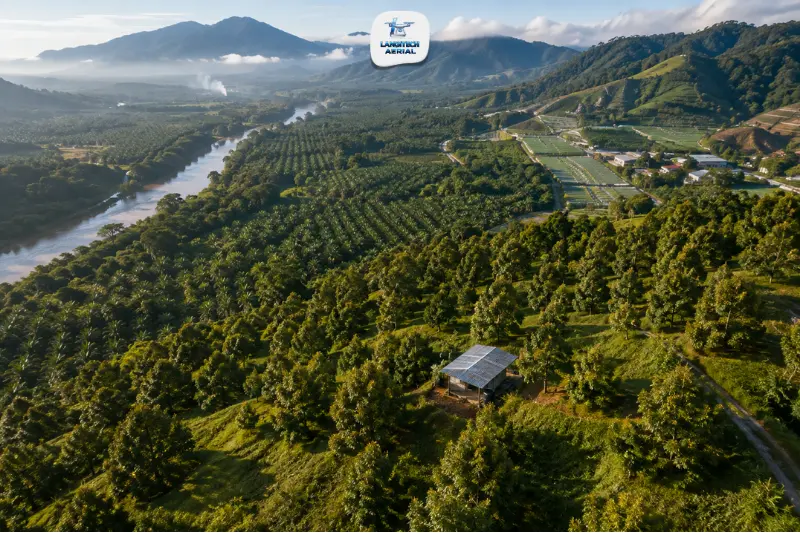
Drone services Pahang Malaysia cover the full range of commercial aerial operations across Malaysia’s largest state: Musang King durian orchards in Raub and Bentong, oil palm estates across the Pahang interior, Cameron Highlands highland agriculture, ECRL construction monitoring along the East Coast Rail Link corridor, and flood mapping along Sungai Pahang. LangiTech Aerial provides CAAM-compliant drone services across Pahang, every deployment fully permitted, RCoC-certified, and documented to the standard that Pahang’s agricultural, construction, and infrastructure sectors require.
Drone services Pahang Malaysia: what we cover
LangiTech Aerial provides four core service lines across Pahang:
- Agriculture drone spraying and spreading — oil palm estates, Musang King and durian orchards, Cameron Highlands highland vegetable farms, rubber plantations, and FELDA scheme oil palm across Pahang
- 3D mapping and survey — topographic surveys, DTM/DSM, stockpile measurement, ECRL construction monitoring, flood corridor mapping, and land development surveys across the state
- Drone cleaning — high-rise building facade and window cleaning for commercial towers and hotels in Kuantan, industrial facility rooftop cleaning, and solar panel maintenance
- Drone spreading — granular fertiliser spreading for Pahang oil palm estates and paddy operations
Pahang agriculture: LangiTech’s primary drone service market
Musang King and durian orchards: Raub, Bentong, Lipis
Pahang is Malaysia’s heartland for premium durian production. Raub District produces a significant portion of Malaysia’s Musang King (D197) durian export crop. Bentong and Lipis also host major Musang King and Black Thorn (D200) orchards across hilly terrain at elevations of 100 to 600 metres above sea level.
Drone services Pahang Malaysia for durian orchards focus on two things.
Disease and pest management. Phytophthora palmivora (stem canker and root rot), thrips on flower buds, and fruit borer management all require timely aerial chemical application across orchard terrain that manual spraying teams can’t cover consistently. Our terrain-following drone systems navigate Pahang’s hilly orchard terrain precisely, maintaining consistent spray height above the canopy regardless of slope angle.
Orchard mapping and health monitoring. Multispectral drone surveys of durian orchards pick up early stress signatures in individual trees, flagging Phytophthora-affected trees before symptoms show at ground level. For a detailed guide to hilly terrain drone spraying for orchards, read our drone spraying hilly terrain guide.
Oil palm estates: Pahang interior, FELDA schemes
Pahang has significant oil palm acreage across its interior districts, Maran, Jerantut, Temerloh, and Bera, including major FELDA scheme areas at Jengka, Chini, and Pahang Tengah. These estates and FELDA schemes are an active market for drone spraying covering bagworm control, herbicide delivery, and foliar fertiliser application.
Pahang’s large oil palm estate blocks also create strong economics for grouped drone spraying, where adjacent FELDA settler plots combine into single drone deployments that bring down per-hectare costs significantly.
For FELDA-specific drone spraying guidance, read our FELDA drone spraying Malaysia guide.
Cameron Highlands: highland agriculture
Cameron Highlands District produces a significant share of Malaysia’s cool-climate vegetables, tea, strawberries, and floriculture crops. Highland vegetable farms on slopes of 15° to 35° need terrain-following drone spraying for Sigatoka management on banana, diamondback moth control on brassicas, and fungicide application for grey mould and downy mildew in the humid highland conditions.
LangiTech Aerial configures flight parameters specifically for highland slope gradients and uses fine-droplet settings that delicate vegetable crops require. For a guide to highland agriculture drone spraying, read our vegetable drone spraying Malaysia guide.
Drone mapping services in Pahang
ECRL construction monitoring
The East Coast Rail Link (ECRL) is Malaysia’s largest active infrastructure project. Pahang’s segment runs through the state’s interior from the Kelantan border through to Pahang’s western exit, covering significant tunnelling, viaduct construction, and surface earthworks across challenging terrain.
Drone services Pahang Malaysia for ECRL-related projects cover:
- Monthly earthworks progress monitoring along the Pahang alignment
- Tunnel portal and viaduct construction documentation
- Cut and fill earthworks BOQ reconciliation for main contractors and JV partners
- Corridor terrain mapping for access road and haul road design
For a full guide to corridor survey applications, read our drone corridor mapping Malaysia guide.
Pahang River flood mapping
Sungai Pahang, Malaysia’s longest river at 459 kilometres, drains most of Pahang’s interior and discharges into the South China Sea near Pekan. Annual northeast monsoon flooding along the Pahang River corridor regularly affects Temerloh, Maran, and downstream areas.
Drone services Pahang Malaysia for flood risk management support JPS Pahang with:
- Pahang River corridor orthomosaic and terrain mapping for flood modelling
- Post-flood damage assessment surveys along affected communities
- Drainage infrastructure condition mapping for flood mitigation design
For a full guide to drone flood mapping applications, read our drone flood mapping Malaysia guide.
Land development and construction surveys
Kuantan’s role as Pahang’s economic capital, with the Kuantan Industrial Estate, Malaysia-China Kuantan Industrial Park (MCKIP), and Kuantan Port expansion, drives active construction and land development activity. Drone services Pahang Malaysia cover:
- Pre-development topographic surveys for Kuantan industrial and residential developments
- Earthworks monitoring and cut-fill BOQ verification for active construction sites
- Stockpile measurement for Gebeng and Kuantan industrial zone operators
For a complete construction survey guide, read our drone earthworks Malaysia guide.
CAAM compliance for drone services Pahang Malaysia
Every LangiTech Aerial deployment across Pahang is fully CAAM-compliant:
- CAAM ATF — applied at least 14 working days before every deployment from CAAM
- RCoC-B + Module 2 (AGR) — all agricultural pilots carry the agricultural operations endorsement
- UAWC — company-level CAAM agricultural operations certification
- JUPEM APK permit — for all mapping, survey, and data-capture operations
- Cameron Highlands specific — highland terrain and airspace parameters included in all ATF applications for Cameron Highlands deployments
For full compliance details, read our drone permit Malaysia requirements guide.
Drone services Pahang Malaysia: key applications summary
| Sector | Service | Key areas |
|---|---|---|
| Durian orchards | Spraying + orchard mapping | Raub, Bentong, Lipis |
| Oil palm estates | Spraying + spreading + estate mapping | Maran, Jerantut, Bera |
| FELDA schemes | Drone spraying programmes | Jengka, Chini, Pahang Tengah |
| Highland agriculture | Terrain-following spraying | Cameron Highlands |
| ECRL infrastructure | Progress monitoring + corridor survey | Pahang alignment |
| Flood management | River corridor + catchment mapping | Pahang River basin |
| Industrial/construction | Earthworks + stockpile + as-built | Kuantan, MCKIP, Gebeng |
Frequently asked questions
Does LangiTech Aerial cover Cameron Highlands despite its highland terrain?
Yes. Cameron Highlands operations use terrain-following flight mode, so the drone automatically adjusts altitude in real time to maintain consistent height above sloped farm terrain. All Cameron Highlands deployments include highland-specific ATF parameters in the CAAM application. Contact us with your Cameron Highlands location and crop type for a tailored spraying or mapping proposal.
Can drone spraying be arranged for FELDA settler plots in Pahang?
Yes. LangiTech Aerial provides drone spraying for FELDA settler oil palm plots across Pahang, individually or as grouped block programmes with neighbouring settlers. Grouped deployments bring down per-hectare costs significantly. Contact your FELDA field officer or reach LangiTech directly to discuss programme scheduling for your Pahang FELDA scheme.
How far in advance should Pahang projects be booked?
For agricultural spraying in Pahang, book at least 3 to 4 weeks before your required treatment date. This covers the 14 working days needed for CAAM ATF processing plus scheduling buffer, particularly during peak durian season (June to August). Mapping and survey projects also need 3 to 4 weeks. Cameron Highlands deployments may need extra lead time for the highland airspace ATF parameters.
Conclusion
Drone services Pahang Malaysia from LangiTech Aerial cover the full range of aerial service requirements across Malaysia’s largest and most topographically varied state. Musang King durian orchards on Raub hillsides, FELDA oil palm schemes in the interior, Cameron Highlands highland vegetable farms, ECRL construction monitoring, Pahang River flood mapping: LangiTech brings CAAM-compliant, professionally documented drone services to every part of Pahang.
Contact LangiTech Aerial to discuss your Pahang project and get a quote.
Need Help Planning a Compliant Drone Project in Malaysia?
Speak with our team about commercial drone operations, compliance requirements, and the right aerial solution for your project.