
3D Mapping & Surveying
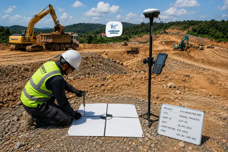
RTK is the question engineers, developers, and project managers ask most before commissioning a drone mapping project. In short, do we need RTK, or are GCPs enough? The answer sets the cost, the fieldwork, and whether the deliverables meet your accuracy specification. So this guide explains what RTK is, how it compares to GCP and PPK, what accuracy each method reaches on Malaysian projects, and how to match the right method to your application.
Key Takeaways
- RTK drone survey reaches 1 to 3 cm horizontal accuracy in real time. As a result, it removes or sharply reduces the need for physical Ground Control Points on most projects.
- Some Malaysian projects need third-party verifiable accuracy, such as JKR engineering submissions, CIPAA evidence, or Licensed Land Surveyor deliverables. For those, combining RTK with a few check points is best practice.
- Malaysian surveys should specify GDM2000 (Geodetic Datum Malaysia 2000) as the coordinate reference system, not WGS84 alone. This keeps them compatible with JUPEM’s national geodetic network.
- PPK (Post-Processed Kinematic) delivers accuracy similar to RTK. However, it applies corrections after the flight rather than in real time, which helps when correction signals are unavailable.
What Is RTK and Why Does It Matter?
Standard GNSS (GPS) positioning fixes a drone’s location to 1 to 5 metres. That is fine for general aerial photography. However, it is far too coarse for engineering survey deliverables that need centimetre accuracy.
RTK (Real-Time Kinematic) corrects this. An RTK drone receives real-time correction signals from a ground base station or a network service (NTRIP). These corrections remove the timing and atmospheric errors that degrade standard GPS. As a result, positioning reaches 1 to 3 cm horizontal accuracy during the flight.
Every image the drone captures is then tagged with these corrected coordinates. Next, photogrammetry software uses those precise image positions to build a 3D model tied to real-world coordinates. So it does this without physical Ground Control Points staked across the site.
The practical benefit is significant. Non-RTK drone mapping without GCPs can produce a model that floats metres above its true elevation. Its relative geometry looks correct, yet it sits displaced from real-world coordinates. By contrast, RTK removes that displacement and anchors the model accurately from the moment of capture.
Three Methods: RTK, GCP, and PPK
Knowing the three main positioning methods helps you specify the right approach.
RTK: Real-Time Kinematic
RTK corrects GPS errors during flight. The signal comes from a base station at a known on-site coordinate, or from a network correction service. Throughout the flight, the drone holds a confirmed “Fixed RTK solution.” In other words, real-time correction is active and positioning is accurate to 1 to 3 cm.
RTK also cuts post-processing time sharply, by up to 90% in documented workflows. The reason is simple. The positioning data is already precise when the images reach the processing stage. So no GCP coordinate entry or bundle adjustment against physical targets is needed.
GCPs: Ground Control Points
Ground Control Points are physical targets placed at known, accurately surveyed coordinates. During processing, the software finds each target in the images. Then it uses their known coordinates to anchor the 3D model to real-world positions.
GCPs reach the same accuracy as RTK when placed and surveyed well. However, they add fieldwork. You have to place targets across the site, survey their coordinates with a GNSS rover or total station, and record them in the correct datum before processing. On large or access-restricted sites, that fieldwork adds real time and personnel.
The key advantage of GCPs is independent verification. A GCP with coordinates from a separate GNSS survey gives a third-party verifiable accuracy check. RTK-only positioning cannot produce that check on its own. So by 2026, most enterprise workflows combine both. They fly an RTK drone for efficiency and hold back a few GCPs as check points to validate the final model.
PPK: Post-Processed Kinematic
PPK records raw GNSS data on the drone and a ground base station separately during the flight. Afterward, software combines the two datasets and applies corrections. As a result, it reaches accuracy similar to RTK without a real-time correction link in flight.
PPK is useful in Malaysia when real-time correction networks are unavailable. For example, remote plantation areas, highland terrain, and locations with poor mobile coverage for NTRIP all suit it. In fact, LangiTech uses PPK workflows where RTK real-time correction is unreliable due to signal coverage.
Accuracy Comparison: RTK vs GCP vs PPK
| Method | Horizontal Accuracy | Vertical Accuracy | GCPs Required | Processing Speed |
|---|---|---|---|---|
| Standard GNSS (no correction) | ±1 to 5 m | ±2 to 10 m | Mandatory | Fast |
| GCPs only (5+ well-distributed) | ±1 to 3 cm | ±2 to 5 cm | Yes, 5 to 15 | Moderate |
| RTK drone (fixed solution) | ±1 to 3 cm | ±3 to 8 cm | Reduced / check points only | Fast |
| PPK post-processed | ±1 to 3 cm | ±3 to 8 cm | Reduced / check points only | Moderate |
| RTK + GCP check points | ±1 to 3 cm | ±1 to 3 cm | 3 to 5 check points only | Fast |
For most Malaysian construction, land development, and plantation projects, RTK gives enough accuracy without a full GCP setup. Adding 3 to 5 check points helps further. These are not full GCPs but independently surveyed verification points. As a result, they provide the accuracy validation that project engineers and JKR supervising officers increasingly expect.
Malaysian Coordinate Systems: GDM2000 and JUPEM
This is a technical requirement specific to Malaysia. Most global RTK guides skip it.
Any Malaysian survey that integrates with national spatial data or JUPEM records should specify GDM2000 (Geodetic Datum Malaysia 2000) as the horizontal reference system. Indeed, GDM2000 is Malaysia’s national geodetic datum. It is the standard used by JUPEM, licensed land surveyors, and government agencies across Peninsular Malaysia.
WGS84 is the global datum that GPS and most drone systems use by default. It is close to GDM2000, but not identical. For most engineering work, such as earthworks BOQ, progress monitoring, and topographic surveys, the difference is negligible. However, some projects need coordinates that tie into JUPEM cadastral data, state land records, or official mapping layers. For those, specifying the GDM2000 transformation matters.
Similarly, MRSO (Malayan Rectified Skewed Orthomorphic) is Malaysia’s legacy projected system. It still appears in older cadastral and engineering drawings. Most modern civil projects now use GDM2000 / RSO projection for new deliverables. Still, always check your client’s CAD or GIS coordinate requirement before processing.
So when you brief a provider, confirm two things. First, what coordinate reference system the deliverables will use. Second, how they tie to the JUPEM benchmark network.
Which Method Does Your Project Need?
Use this guide before you brief your provider.
Use RTK Only When:
- You run construction progress monitoring, such as monthly earthworks tracking.
- You map oil palm estates for palm counting and infrastructure mapping.
- You need plantation topographic surveys for replanting layout planning.
- The site is large and GCP fieldwork is impractical, above 100 hectares.
Use RTK + Check Points When:
- You submit JKR road and highway surveys to supervising consultants.
- You document housing development earthworks for HDA milestones.
- You need CIPAA adjudication evidence with independently verifiable accuracy.
- A third party will review your accuracy claims.
Use Full GCP Networks When:
- Licensed Land Surveyor certified deliverables are required.
- The contract specifies strict tolerance, such as ±2 cm or tighter.
- Boundary accuracy matters on cadastral-adjacent surveys.
When You Need a Licensed Land Surveyor
Drone RTK survey does not replace a Licensed Land Surveyor for cadastral and boundary work in Malaysia, whatever accuracy it reaches. Under the Licensed Surveyors Act 1958, certain surveys must be done by or under a Licensed Land Surveyor registered with the Board of Surveyors Malaysia. These include cadastral surveys for land title, boundary demarcation, and strata subdivision. So always confirm with your legal adviser whether your project needs LLS certification before relying on drone data alone.
Frequently Asked Questions
What accuracy does RTK drone survey achieve?
With a confirmed Fixed RTK solution throughout the flight, RTK surveys reach 1 to 3 cm horizontal accuracy and 3 to 8 cm vertical accuracy. Adding a few independently surveyed check points then improves verified vertical accuracy to 1 to 3 cm. In practice, these levels cover construction progress monitoring, earthworks BOQ verification, road survey, plantation mapping, and most engineering topographic surveys in Malaysia.
What is the difference between RTK and PPK?
Both reach similar horizontal accuracy of 1 to 3 cm. However, RTK applies corrections in real time during flight. So it needs a reliable base station or NTRIP network signal. PPK instead processes corrections after the flight from raw GNSS data. As a result, it suits remote Malaysian locations where real-time signals are unreliable. For most urban and peri-urban projects in Peninsular Malaysia, RTK is practical. For plantation and highland surveys with poor mobile coverage, PPK is often the better choice.
Do I need GCPs if my provider uses an RTK drone?
For most Malaysian construction and development projects, RTK alone gives enough accuracy without a full GCP setup. This covers earthworks monitoring, progress surveys, topographic mapping, and plantation surveys. However, adding 3 to 5 independently surveyed check points is recommended in some cases. Use them whenever a third party will review accuracy claims, or when deliverables go to JKR, a supervising consultant, or CIPAA adjudication. After all, check points validate the RTK positioning independently, which RTK alone cannot prove to a reviewer.
Conclusion
RTK drone survey takes the positioning uncertainty out of drone mapping. It delivers 1 to 3 cm accuracy in real time, without the full GCP fieldwork that non-RTK surveys need. So for most Malaysian construction, development, plantation, and infrastructure projects, RTK provides the accuracy that engineering and project management applications need.
A few decisions remain. First, whether to add check points for third-party verifiable accuracy. Second, which coordinate reference system your project requires. Third, whether your deliverables need Licensed Land Surveyor certification, which drone surveys do not replace.
LangiTech Aerial uses RTK-enabled drone platforms on all survey projects. It also offers PPK capability for remote locations and check point validation where projects need independently verified accuracy.
Contact LangiTech Aerial to talk through your project accuracy requirements and get a survey quote.
For a full guide to the underlying technology, read our drone photogrammetry Malaysia guide.
Need Help Planning a Compliant Drone Project in Malaysia?
Speak with our team about commercial drone operations, compliance requirements, and the right aerial solution for your project.