
3D Mapping & Surveying
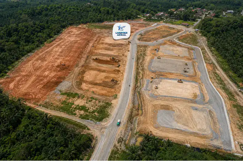
Drone land development gives property developers, project managers, and civil engineering consultants accurate spatial data at every stage of the development lifecycle. That runs from pre-acquisition feasibility through to earthworks completion. A single day of drone fieldwork produces the topographic data that traditional surveyor crews take one to two weeks to match. Moreover, this speed advantage compounds at each stage of a programme. As a result, it shortens feasibility studies, speeds up planning submissions, and enables weekly earthworks monitoring that prevents BOQ disputes. So this guide maps every drone survey application across the Malaysian property development lifecycle.
Key Takeaways
- Drone land development covers five survey stages: pre-acquisition feasibility, planning submission topographic mapping, infrastructure design, earthworks BOQ and monitoring, and as-built documentation.
- A pre-acquisition feasibility survey of a 20-hectare candidate site usually finishes in one day. It also costs far less than a formal Licensed Land Surveyor engagement, while still giving enough data for earthworks and planning assessment.
- Malaysian civil engineers use drone DTMs as the primary input for MSMA (Manual Saliran Mesra Alam) stormwater drainage design. In short, accurate terrain is the foundation of every development’s drainage plan.
- Every drone land development operation needs a CAAM ATF and a JUPEM APK aerial data permit before deployment.
Why Drone Surveys Are Now Standard in Malaysian Land Development
Malaysian property development is an active, capital-intensive sector. Developers registered with REHDA (Real Estate and Housing Developers’ Association Malaysia) run projects of every size. These range from small township phases to large integrated developments of thousands of hectares across Selangor, Johor, Penang, Pahang, and other growth states.
Every project needs accurate spatial data at several decision points. Crucially, the speed of that data affects timelines and costs directly. Traditional ground survey produces data slowly, at sparse point density, and with the disruption of crews on sites that may lack access roads or cleared paths.
Drone land development has changed this. A survey of a 20-hectare site takes one day of flight operations. Yet it produces 50 to 100 times the point density of a traditional total station survey. Furthermore, the output covers orthomosaic, DTM, contour lines, and point cloud. So every discipline in the team gets the full dataset at once, from town planners to drainage engineers to earthworks contractors.
Stage 1: Pre-Acquisition Feasibility Survey
Before a developer commits to buying a parcel, they need to understand what the land actually is. That means its topography, drainage patterns, existing structures, access conditions, and any features that complicate development.
Traditionally, this meant engaging a Licensed Land Surveyor for a formal topographic survey. However, that process takes weeks and costs significantly before a purchase is even confirmed. Drone land development changes this feasibility workflow entirely.
A drone survey of a candidate site produces a high-resolution orthomosaic and DTM in a single day. Better still, it can run even before the developer holds the land title. In practice, this data supports:
- Earthworks volume estimation: DTM-based cut-fill calculations give a preliminary earthworks cost estimate before you commit to acquisition.
- Drainage constraint identification: Low-lying areas, natural drains, and potential waterlogging zones show up in the DTM and orthomosaic.
- Access assessment: Existing tracks, topographic barriers, and neighbouring road connections are clearly mapped.
- Development compatibility: The orthomosaic reveals neighbouring land uses, utility corridors, and encumbrances that affect feasibility.
This survey does not replace the formal Licensed Land Surveyor engagement for title and boundary work. However, it delivers feasibility-level intelligence at a fraction of the cost and time. As a result, developers make faster, better-informed acquisition decisions.
Stage 2: Planning Submission Topographic Map
After acquisition, the Malaysian planning process requires a topographic map. It forms part of the Development Order (DO) application to the local council (PBT, Pihak Berkuasa Tempatan). This map must show existing terrain contours, drainage features, vegetation, existing structures, and access conditions across the full site.
Drone land development produces this dataset to the standard required for OSC (One Stop Centre) submission. That includes the orthomosaic, contour lines at 0.5 or 1 metre intervals, and the key site features.
Furthermore, many councils now require stormwater drainage management plans under MSMA (Manual Saliran Mesra Alam) guidelines in the submission package. MSMA design is terrain-dependent. Specifically, the drainage engineer uses the site DTM to set sub-catchment boundaries, flow directions, and retention basin sizing. So an accurate drone-derived DTM feeds directly into the MSMA documentation that planning submission requires.
Stage 3: Infrastructure Design Surveys
After planning approval, infrastructure design begins. This covers roads, sewers, drainage channels, retention ponds, and utility corridors. Every one of these elements needs accurate terrain data as its base.
Drone land development provides the design survey dataset that replaces or supplements the traditional total station survey at this stage:
- Road design: DTM-derived cross-sections along proposed alignments feed road design software. In turn, that drives horizontal and vertical alignment, cut-fill balance, and gradient design.
- Drainage design: Drone-derived DTMs define the catchment topology, flow paths, and pond sizing that engineers use in hydraulic modelling for MSMA compliance.
- Utility corridor planning: Orthomosaic base maps let utility corridors for water, sewage, electrical, and telecoms be laid out in AutoCAD against current aerial imagery. As a result, clashes with existing features surface before construction begins.
Stage 4: Earthworks Tendering and Monitoring
Earthworks is usually the largest single cost item in Malaysian land development. On sloped or complex terrain, it often represents 20% to 40% of total development cost. So accurate earthworks volume data is a critical financial control at two points: contractor tendering and monthly progress payment.
Earthworks BOQ Tendering
Before tendering earthworks contracts, developers and project managers prepare a Bill of Quantities (BOQ). It specifies cut and fill volumes per zone. Drone land development supplies the pre-earthworks ground surface DTM. Then it compares that against the approved design surface to generate precise BOQ volumes per block.
These volumes beat estimates from sparse design survey data. After all, the drone captures the full existing terrain, not just the points where teams placed total station shots. As a result, tenders based on drone BOQ produce more reliable pricing and fewer variation claims during execution.
Monthly Earthworks Progress Monitoring
During execution, monthly drone surveys compare the current ground surface against the design surface. They quantify volumes moved per zone and flag sections that run behind or ahead of programme. So this data supports monthly progress payment certification. It also provides the independent record that prevents earthworks quantity disputes.
For a detailed guide to earthworks volume measurement, read our drone cut fill Malaysia guide.
Stage 5: Infrastructure As-Built Survey
After earthworks and infrastructure are complete, developers need as-built surveys. These come before submitting for Certificate of Completion and Compliance (CCC) or Strata Title applications. Drone land development provides as-built orthomosaics and terrain models that document:
- Final formation levels across the development area
- Road alignments and grades as constructed
- Drainage channel positions, sizes, and invert levels
- Retention pond positions and design surface confirmation
These records support CCC applications. Moreover, they give future development phases, facility management teams, and JMBs a baseline for estate management.
Survey Requirements by Stage
| Development Stage | Survey Type | Key Deliverables |
|---|---|---|
| Pre-acquisition feasibility | Orthomosaic + DTM | Feasibility orthomosaic, preliminary earthworks estimate |
| Planning submission | Topographic survey | 0.5/1 m contours, MSMA drainage input DTM |
| Infrastructure design | Design survey | DTM, cross-sections, road/drainage design base |
| Earthworks tendering | BOQ survey | Cut-fill volumes per zone, existing ground DTM |
| Earthworks monitoring | Progress survey (monthly) | Cut-fill progress maps, remaining volume report |
| As-built documentation | As-built survey | Final formation levels, road and drainage as-built |
CAAM and JUPEM Compliance
Every drone land development operation needs two approvals.
CAAM ATF: First, all commercial drone operations need an Authorisation to Fly from CAAM, applied for at least 14 working days before deployment. For sites in urban or peri-urban locations, the ATF application covers flight near existing residential areas, roads, and infrastructure.
JUPEM APK Permit: Drone land development surveys also capture georeferenced aerial data. Because of that, they trigger the JUPEM aerial data acquisition security clearance. For programmes that run multiple survey stages over an extended period, use one programme-level APK covering the full project duration. It is more efficient than separate applications per survey visit.
For a full permit guide, read our drone permit Malaysia requirements guide.
Frequently Asked Questions
Can a drone survey replace a Licensed Land Surveyor for Malaysian land development?
Not for boundary and title work, but yes for topographic and feasibility surveys. Under the Licensed Surveyors Act 1958, cadastral surveys, boundary demarcation, and title-related surveys must be done by or under a Licensed Land Surveyor registered with the Board of Surveyors Malaysia. However, drone topographic surveys for planning submission, earthworks design, and feasibility do not need LLS certification. Moreover, they deliver higher point density and faster turnaround than traditional methods for these applications.
What format do Malaysian civil engineers need for drone survey deliverables?
Malaysian consultants and contractors mainly work in AutoCAD Civil 3D and Microstation. So the most useful deliverables are DXF contour files for AutoCAD, LandXML or DWG TIN surfaces for Civil 3D earthworks analysis, and GeoTIFF orthomosaics for reference base mapping. Before processing begins, confirm your design team’s platform and coordinate system. GDM2000 / RSO is standard for most Malaysian projects.
How does a drone DTM support MSMA drainage design in Malaysia?
MSMA (Manual Saliran Mesra Alam) design needs accurate sub-catchment boundaries, flow path definitions, and retention basin sizing. All of these are terrain-dependent. Drainage engineers input the site DTM into hydrological modelling software to define catchment topology and design the system. A drone-derived DTM at 10 to 50 cm resolution gives far more accurate catchment definition than a sparse total station survey. As a result, it improves both the quality and the regulatory compliance of the drainage design in the planning package.
Conclusion
Drone land development supports every stage of the property development lifecycle. It runs from pre-acquisition feasibility surveys that take one day instead of weeks, through planning submission mapping, MSMA drainage input, earthworks tendering BOQ, monthly monitoring, and final as-built documentation.
The cumulative value across a full programme is significant. Faster feasibility decisions, more accurate earthworks BOQs, fewer payment disputes, and cleaner as-built records all improve project outcomes. Better still, the survey data costs only a fraction of the earthworks contract value on any moderately sized Malaysian development.
LangiTech Aerial provides CAAM and JUPEM-compliant drone land development survey services across Peninsula Malaysia. This covers property developers, project management consultants, and civil engineering firms.
Contact LangiTech Aerial to talk through your development survey and get a stage-by-stage programme quote.
For a broader look at the underlying technology, read our drone photogrammetry Malaysia guide.
Need Help Planning a Compliant Drone Project in Malaysia?
Speak with our team about commercial drone operations, compliance requirements, and the right aerial solution for your project.