
3D Mapping & Surveying
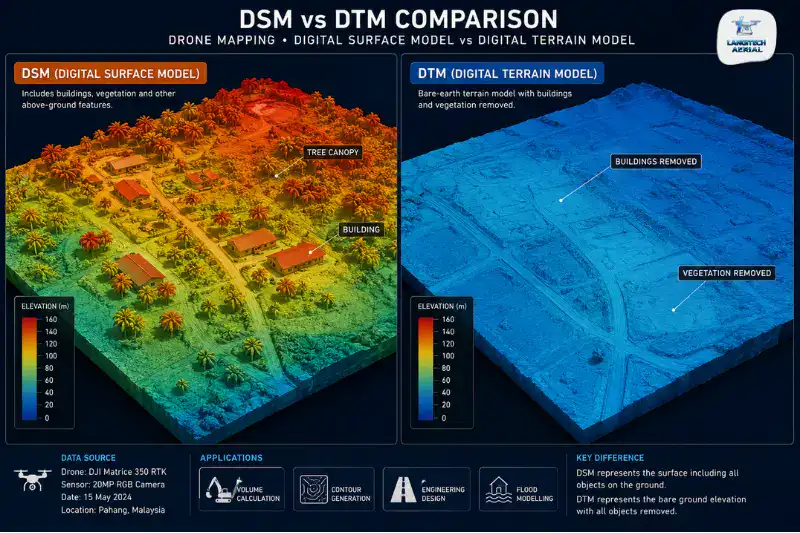
Drone DTM is one of the most commonly misspecified deliverables in Malaysian construction and development surveying. Engineers and developers ask for a DTM, a Digital Terrain Model that shows bare-earth ground elevation. However, they often receive a DSM instead, a Digital Surface Model that includes buildings, trees, and every above-ground feature. On open construction sites, this distinction barely matters. On oil palm estates, forested land, and sites with significant structures, it matters a lot. In those cases, using a DSM where a DTM is needed produces wrong drainage designs, incorrect earthworks volumes, and flawed road grades. So this guide explains what each model is, which Malaysian applications need which one, and how to specify correctly when you brief a provider.
Key Takeaways
- A DTM (Digital Terrain Model) shows the bare-earth ground surface only, with vegetation and structures removed. A DSM (Digital Surface Model) shows everything on the ground, including buildings and canopy.
- MSMA drainage design, earthworks cut-fill, and road design all require a DTM. A DSM produces wrong results, because vegetation and structures block natural flow paths and inflate ground elevations.
- RGB photogrammetry produces a DSM by default. So on vegetated sites, LiDAR is required to penetrate the canopy and generate a true DTM.
- Always confirm whether the delivered model is a DTM or DSM. On vegetated Malaysian sites, also confirm which sensor and processing method produces your bare-earth model.
The Three Elevation Models: DEM, DTM, and DSM
DEM: Digital Elevation Model
DEM is the umbrella term for any digital representation of ground elevation. Both DTMs and DSMs are DEMs. So when a Malaysian engineer asks for a “DEM” without specifying, they may receive either. That is exactly why specifying DTM or DSM explicitly matters.
DTM: Digital Terrain Model
A DTM represents the bare-earth surface. In other words, it shows the ground as it would look with all vegetation, buildings, and above-ground structures removed. So it captures only the natural topography of the terrain.
DTMs are essential for:
- Earthworks cut-fill calculations and grading design
- MSMA stormwater drainage catchment analysis and flow path modelling
- Road horizontal and vertical alignment design
- Flood risk inundation modelling
- Plantation replanting terrace design
The key trait of a DTM is that it reveals how water actually flows across the ground. Crucially, that flow is unobstructed by vegetation or structures. By contrast, drainage design based on a DSM that includes tree canopy or rooftops gives incorrect flow paths and catchment areas.
DSM: Digital Surface Model
A DSM represents the top surface of everything in the scene. That means ground, vegetation canopy, building rooftops, stockpiles, and any above-ground feature. It is also the model that drone photogrammetry produces naturally. After all, cameras capture the top surface of whatever is visible from the air.
DSMs are appropriate for:
- Construction progress monitoring on cleared sites
- Building height and volumetric analysis
- Stockpile volume measurement on open yards
- Canopy height mapping
- Visual documentation and site overview
On cleared sites with no vegetation or structures, a DSM is effectively a DTM. The reason is simple. The only surface visible is the ground.
The Critical Malaysian Issue: Photogrammetry Gives DSM, Not DTM
This is the most important point for Malaysian drone survey clients. It is also the one that global guides consistently skip.
RGB photogrammetry is the standard drone mapping workflow, and it uses a camera. So it captures the top of whatever is visible from the air. On vegetated terrain, the camera sees the top of the canopy, not the ground beneath it. As a result, the elevation model is a DSM of the canopy surface, not a DTM of the bare ground.
For Malaysian projects, this matters in three specific scenarios.
Oil Palm Estates
Drone photogrammetry over a mature oil palm block captures the canopy surface at 10 to 15 metres, not the ground at 0 metres. So the resulting DSM shows a fairly uniform elevated surface that follows the canopy tops. Any drainage design or replanting terrace plan built on this DSM uses the canopy elevation as its terrain reference. As a result, it produces completely wrong results.
Some estates need bare-earth DTM data for replanting layout, drainage, or road planning. For those, LiDAR is the only viable sensor. LiDAR laser pulses pass through gaps in the palm canopy and return ground-level measurements. In turn, that produces a true bare-earth DTM beneath the plantation.
Forested Land Development Sites
Pre-development land in Malaysia often carries secondary forest, plantation cover, or mature trees. Drone photogrammetry of this terrain produces a DSM of the forest canopy, not the ground beneath it. However, earthworks design, drainage planning, and the cut-fill calculations for tendering all need a bare-earth DTM. LiDAR processing solves this. It filters out canopy returns and keeps only ground returns, so it produces the required DTM.
Construction Sites with Significant Structures
Some construction sites are partly developed, with completed buildings, walls, access roads, and drainage. On these, photogrammetry produces a DSM that includes all those above-ground features. For earthworks volume calculations against the design surface, a filtered DTM works better. It excludes construction equipment, stockpiles, and temporary structures, so it gives more accurate cut-fill volumes than an unfiltered DSM.
When Photogrammetry DTM Is Acceptable
On cleared, open terrain, photogrammetry produces a model that closely approximates a DTM. This covers actively graded earthworks areas, cleared development pads, open quarry sites, and bare agricultural land. With no vegetation or significant structures present, the camera captures the ground surface directly.
For Malaysian earthworks monitoring, monthly photogrammetry surveys on cleared active sites work well. They produce terrain models accurate enough for cut-fill volumes and progress monitoring. In practice, the ground visibility makes the DTM versus DSM distinction largely irrelevant here.
Therefore, for open-site applications, the photogrammetry drone DTM workflow is both accurate and cost-effective. So reserve LiDAR for forested, plantation, or structurally complex terrain, where ground visibility is genuinely obstructed.
DTM vs DSM: Malaysian Application Decision Table
| Application | Model Required | Sensor to Use |
|---|---|---|
| MSMA drainage catchment design | DTM | LiDAR (vegetated) / Photogrammetry (cleared) |
| Earthworks cut-fill on cleared site | DTM (effectively DSM on cleared ground) | Photogrammetry |
| Road design, alignment and grades | DTM | LiDAR (forested) / Photogrammetry (cleared) |
| Flood risk inundation modelling | DTM | LiDAR |
| Oil palm replanting layout | DTM | LiDAR |
| Construction progress monitoring | DSM | Photogrammetry |
| Stockpile volume measurement | DSM | Photogrammetry |
| Building height analysis | DSM | Photogrammetry |
| Canopy health / NDVI analysis | DSM | Multispectral photogrammetry |
| Planning submission topographic map | DTM (cleared) or LiDAR DTM (vegetated) | Context-dependent |
How to Specify Drone DTM Correctly
When you brief a drone survey provider, ask these specific questions.
1. What elevation model will the survey produce, DTM or DSM?
On any vegetated site, confirm this explicitly. Do not assume photogrammetry produces a DTM on forested or plantation terrain.
2. If a DTM is required on vegetated terrain, what sensor will achieve it?
The answer must be LiDAR. Suppose your provider proposes photogrammetry for bare-earth DTM on oil palm or forest. Then the deliverable will be a canopy DSM, not a ground DTM.
3. What file format will the model be delivered in?
For AutoCAD Civil 3D workflows, which are standard in Malaysian civil engineering, specify GeoTIFF for raster DTM and LandXML or DWG TIN surface for the vector model. For ArcGIS or QGIS, specify ASC or GeoTIFF instead.
4. What coordinate system will the model use?
Specify GDM2000 / RSO projection for compatibility with JUPEM data and Malaysian national mapping. For full coordinate system guidance, read our RTK drone survey Malaysia guide.
Frequently Asked Questions
What is the difference between DTM and DSM in drone surveys?
A DTM (Digital Terrain Model) shows only the bare-earth ground surface, with vegetation and structures removed. A DSM (Digital Surface Model) shows the top of everything, including ground, buildings, vegetation canopy, and any above-ground feature. So for drainage design, road design, and earthworks, a DTM is required. For construction progress monitoring and visual documentation, a DSM is enough.
Can drone photogrammetry produce a DTM in Malaysia?
It depends on the terrain. On cleared, open terrain, such as active construction sites, graded earthworks areas, and open quarries, photogrammetry produces a model that closely approximates a DTM, because the camera captures the bare ground directly. However, on vegetated terrain, such as oil palm estates, secondary forest, or plantation, photogrammetry captures the canopy surface and produces a DSM instead. So LiDAR is required for a true bare-earth DTM on vegetated Malaysian terrain.
Which elevation model does MSMA drainage design in Malaysia require?
MSMA drainage design requires a DTM, meaning a bare-earth terrain model. A DSM produces incorrect flow paths and catchment boundaries, because buildings and vegetation obstruct natural drainage directions in the model. Therefore, drainage engineers running MSMA hydraulic calculations must confirm that the delivered model is a bare-earth DTM. This matters most on partially vegetated or structurally complex sites.
Conclusion
Drone DTM deliverables are only correct when the sensor and processing method match the terrain. On cleared construction and development sites, photogrammetry efficiently produces the bare-earth equivalent that engineering design needs. However, on vegetated oil palm estates, forested land, and sites with significant structures, LiDAR is essential for a true bare-earth DTM.
The practical rule is simple. First, always specify DTM or DSM explicitly when you brief a provider. Second, confirm the sensor being used on vegetated terrain. Third, verify the output coordinate system matches your engineering platform before processing begins.
LangiTech Aerial provides drone DTM surveys using both photogrammetry and LiDAR, matched to your terrain condition and engineering deliverable.
Contact LangiTech Aerial to talk through your elevation model requirements and get a survey quote.
For broader drone mapping guidance, read our drone photogrammetry Malaysia guide and our LiDAR drone survey Malaysia guide.
Need Help Planning a Compliant Drone Project in Malaysia?
Speak with our team about commercial drone operations, compliance requirements, and the right aerial solution for your project.