
3D Mapping & Surveying
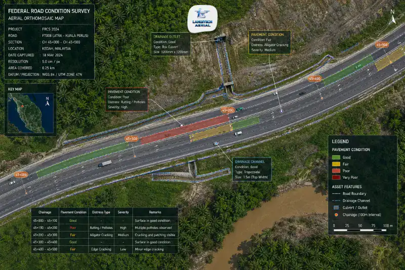
Drone road survey gives JKR engineers, highway concessionaires, and road construction project managers accurate spatial data along road corridors, faster and cheaper than a traditional ground survey team. Malaysia’s road network is one of the largest in Southeast Asia, with JKR managing 20,017 kilometres of federal roads and over 285,000 kilometres of state roads. Maintaining, upgrading, and documenting that network creates steady demand for fast, accurate road survey data, and drone technology is well suited to supply it. This guide covers what a drone road survey delivers, where it fits, and what it cannot replace.
Key Takeaways
- Drone road survey produces high-resolution orthomosaics, terrain models, and corridor data for JKR maintenance programmes, highway concessionaires, and road construction earthworks contracts.
- The most valuable applications are pre-design topographic surveys for road widening, earthworks BOQ verification, road marking condition documentation, and drainage infrastructure mapping.
- Drones produce excellent visual condition data but do not replace pavement structural assessment. IRI roughness measurement and bearing capacity testing still need ground-based equipment.
- Every drone road survey needs a CAAM ATF and a JUPEM APK aerial data permit before deployment.
What Drone Road Survey Delivers
Drone road survey is not one service. It covers several distinct survey types, each serving a different point in the road project lifecycle.
Pre-Construction Topographic Survey
Before road widening, realignment, or new construction starts, engineers need an accurate terrain model of the existing road corridor and the land beside it. A drone topographic survey produces a DTM and orthomosaic of the full corridor, capturing the road surface, drainage channels, embankments, retaining structures, and surrounding terrain in a single dataset.
That data feeds straight into road design software. AutoCAD Civil 3D and Bentley OpenRoads Designer are the standard platforms for JKR road design consultants. The survey establishes the existing ground model that earthworks cut and fill volumes are calculated from. That makes pre-construction drone surveys on road widening projects, the active 2-lane to 4-lane upgrading programme across Peninsular Malaysia, one of the most commercially significant uses of the technology.
Earthworks BOQ Verification
Active road construction contracts need ongoing volume reconciliation between the contractor’s claimed earthworks quantities and the volumes actually moved. On an active site, a drone survey produces monthly DTMs that support accurate cut-and-fill volume calculations by section, so JKR engineers and supervising consultants can check contractor progress claims against independently measured quantities.
When disputes come up over earthworks volumes, which is a common source of contractor-employer conflict on Malaysian road jobs, the survey data gives you objective, georeferenced, date-stamped evidence of ground conditions at specific dates through the contract.
Pavement Condition Visual Mapping
High-resolution drone orthomosaics flown at 30 to 50 metres above the road capture pavement conditions at 1 to 2 cm per pixel. That is sharp enough to identify and map:
- Surface cracking, including longitudinal, transverse, and alligator patterns
- Pothole locations and rough extent
- Edge deterioration and shoulder failures
- Road marking condition, such as faded lines, missing symbols, and worn stop bars
- Drainage channel blockage and vegetation growth along road edges
- Patching locations and approximate area
Drone-generated condition maps let JKR maintenance teams and maintenance contractors prioritise repairs across long sections without sending crews to walk or drive every kilometre.
Road Marking Documentation
Road markings such as lane lines, chevrons, stop bars, directional arrows, and pedestrian crossings fade under Malaysia’s tropical sun and heavy rain. Documenting marking condition periodically is a maintenance obligation for JKR and highway concessionaires.
A drone survey produces georeferenced orthomosaics that record marking condition across the full length. Assessment teams use them to build marking replacement schedules, pick priority locations, and work out repainting quantities for contractor tendering.
Drainage Infrastructure Mapping
Road drainage such as culverts, side drains, monsoon drains, and retention basins is critical infrastructure that JKR maintenance teams inspect and maintain regularly. Drone orthomosaics capture the visible condition and extent of that drainage along road corridors, which supports maintenance planning and asset inventory updates.
What Drone Road Survey Cannot Do
This is the line that separates professional drone providers from those who oversell what a drone can do.
IRI (International Roughness Index) measurement: IRI quantifies the longitudinal roughness that drivers feel as ride quality. It needs ground-contact equipment, either a vehicle-mounted laser profilometer or a rolling straight-edge device. Drone cameras cannot measure roughness. What a drone can do is add visual condition mapping alongside the IRI index for the same section.
Structural bearing capacity testing: FWD (Falling Weight Deflectometer) and DCP (Dynamic Cone Penetrometer) tests assess pavement structural capacity, which is a core input for rehabilitation design. Both are ground-contact tests that a drone cannot perform.
Sub-surface condition: Pavement failure often starts in the base course or subgrade, below what a drone camera sees. Ground-penetrating radar (GPR) surveys detect sub-surface moisture ingress and layer defects that orthomosaics do not show.
A professional provider states these limits plainly and recommends a combined approach where both aerial and ground-based data are needed.
Key Malaysian Road Survey Clients and Applications
JKR Malaysia: Federal and State Road Maintenance
JKR handles federal road maintenance through appointed contractors on periodic maintenance contracts. Those contractors need accurate road condition documentation for maintenance planning and JKR compliance reporting. A drone survey gives them fast condition mapping across long sections, which supports maintenance prioritisation across the 20,017-kilometre federal network.
State road maintenance programmes, run by the respective State Public Works Departments, follow similar procurement models and create the same demand for condition survey data.
Highway Concessionaires: PLUS, APLUS, Gamuda, IJM
Malaysia’s highway concessionaires work under concession agreements that require periodic pavement condition surveys and maintenance documentation for the Highway Planning Unit (Unit Perancang Ekonomi Jalan Raya, UPERJ). A drone survey supports those obligations with high-resolution condition documentation along highway sections, which supplements traditional IRI data with detailed visual mapping.
Road Construction Contractors
Main contractors on JKR road and highway projects use drone surveys for earthworks volume monitoring, subcontractor progress verification, and monthly reporting to the project employer. Monthly surveys along active alignments are becoming standard practice on major road projects across Peninsular Malaysia.
Drone Road Survey vs Traditional Methods
| Factor | Traditional Ground Survey | Drone Road Survey |
|---|---|---|
| Coverage rate | 2 to 5 km per team per day | 20 to 50 km per day |
| Personnel on road | Yes, traffic management required | No, drone operates from safe roadside position |
| Visual condition data | Point-based, selective | Comprehensive, entire road surface captured |
| Earthworks volumes | Total station grid survey | DTM-based cut-fill calculation |
| Road marking condition | Manual walking assessment | Georeferenced orthomosaic |
| IRI roughness | Not measured by either, requires profilometer | Not measured by either |
| Typical mobilisation | 1 to 2 days per 10 km | Half day per 50 km |
The biggest operational advantage on active corridors is that you drop the traffic management. Ground survey teams working on live roads need traffic control crews, road closure approvals, and signage, which is a real cost and logistics burden that drone surveys remove on all but the lowest-altitude flights.
CAAM and JUPEM Compliance
Every drone road survey needs two approvals.
CAAM ATF: All commercial drone operations need an Authorisation to Fly from CAAM, applied for at least 14 working days before the survey. For surveys along active traffic corridors, the ATF application covers the operational parameters for flying next to or over live roads.
JUPEM APK Permit: Because a road survey captures georeferenced aerial data, it triggers the JUPEM aerial data acquisition security clearance. For a long road corridor, one APK application covering the full section beats applying segment by segment.
For a full permit guide, read our drone permit Malaysia requirements guide.
Frequently Asked Questions
Can drone surveys replace JKR pavement condition surveys?
Partly, and it depends on what the survey needs. A drone survey gives you excellent visual condition data, covering cracking, potholes, marking condition, and drainage status, at a scale and speed ground surveys cannot match. What it cannot do is measure IRI roughness or structural bearing capacity. A full JKR pavement management survey usually combines drone visual mapping with vehicle-mounted IRI measurement and periodic FWD structural testing.
How much does a drone road survey cost in Malaysia?
Pricing depends on road length, survey type, and the deliverables. As a rough 2026 guide for the Malaysian market: visual condition orthomosaic only runs RM 500 to RM 1,500 per kilometre for short sections, with lower per-kilometre rates above 10 kilometres. A combined topographic survey with DTM and contour deliverables runs RM 1,500 to RM 4,000 per kilometre for short sections. Contact LangiTech for a project-specific quote based on your road length, corridor width, and deliverables.
What accuracy does a drone road survey achieve?
With RTK GPS, a drone road survey reaches ±2 to 5 cm horizontal accuracy and ±3 to 8 cm vertical accuracy, which covers earthworks BOQ verification and road design topographic surveys. For road widening projects that need Licensed Land Surveyor certified deliverables, GCP-enhanced surveys tighten accuracy to ±1 to 3 cm. For more on this, read our RTK drone survey Malaysia guide.
Can drones survey active roads with traffic?
Yes, as long as the operation meets CAAM ATF requirements for flight next to or above live roads. The drone works from roadside take-off and landing positions and, in most cases, needs no traffic management or lane closures. This is one of the main advantages over a traditional ground survey crew, who need traffic control whenever they are on the carriageway.
Conclusion
A drone road survey covers the full range of road project survey needs, from pre-construction topographic models for widening design, through earthworks BOQ verification during construction, to pavement condition mapping and road marking documentation for maintenance.
JKR maintenance engineers, highway concessionaire asset teams, and road construction project managers all gain from the speed, scale, and safety a drone survey brings along road corridors, especially the way it removes the traffic management that makes traditional road surveys expensive and complicated.
LangiTech Aerial provides CAAM and JUPEM-compliant drone road survey services across Peninsula Malaysia for federal road, state road, highway, and road construction projects.
Contact LangiTech Aerial to talk through your road survey and get a quote.
For a broader look at the underlying technology, read our drone photogrammetry Malaysia guide.
Need Help Planning a Compliant Drone Project in Malaysia?
Speak with our team about commercial drone operations, compliance requirements, and the right aerial solution for your project.